Villaba geodata
Villaba (Eastern Visayas) is a seat of a third-order administrative division; located in Philippines in Asia/Manila (GMT+8) time zone. With population of 3,266 people, there are 2244 cities with bigger population in this country. Compared to other cities in Philippines, 54.4% of cities are located further ↑North; 77.2% of cities are located further ←West and 89.7% of cities have higher elevation than Villaba. Note1


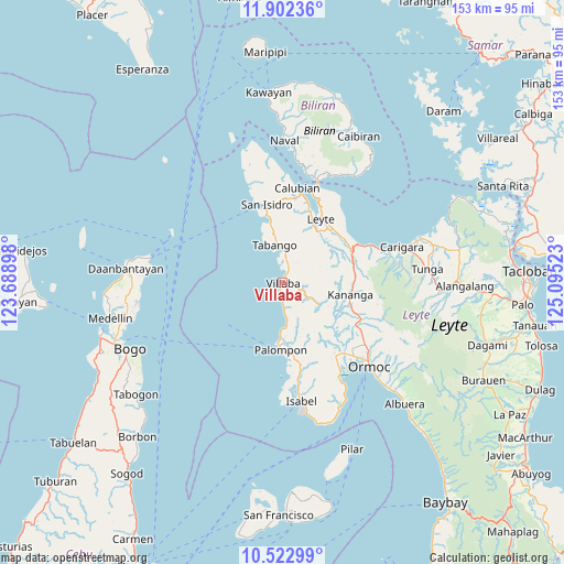
Villaba GPS coordinates[2]
11° 12' 48.6" North, 124° 23' 31.56" East
| Map corner | latitude | longitude |
|---|---|---|
| Upper-left | 11.90236°, | 123.68898° |
| Center: | 11.2135°, | 124.3921° |
| Lower-right: | 10.52299°, | 125.09523° |
| Map W x H: | 153.4×153.4 km | = 95.3×95.3mi |
| max Lat: | 20.78733° ⇑54.4% North |
| Villaba: | 11.2135° |
| min Lat: | ⇓45.6% South 4.65442° |
| min Long | Villaba | max Long |
| 117.04868° | 124.3921° | 126.58417° |
| W 77.2%⇐ | ⇒22.8% E |
Elevation
Elevation of Villaba is 7 m = 23 ft, and this is 80.9 m = 265 ft below average elevation for this country.
| Max E: |
2262 m = 7421 ft | 89.7% |
| Avg. | 87.9 m = 288 ft | |
| Villaba | 7 m = 23 ft | |
Min E: |
-2 m = -7 ft | 10.3% |
See also: Philippines elevation on elevation.city.
Geographical zone
Villaba is located in North Torrid zone (between Equator and Tropic of Cancer). Distance of Equator is 1246.8 km =774.7 mi to South.| Distance of | km | miles | from Villaba |
|---|---|---|---|
| North Pole | 8760.2 | 5443.3 | to North |
| Arctic Circle | 6154.3 | 3824.1 | to North |
| Tropic Cancer | 1359.1 | 844.5 | to North |
| Equator | 1246.8 | 774.7 | to South |


Nearby cities:
15 places around Villaba: (largest is in red/bold)
• Balagtas
16.5 km =10.3 mi,  122°
122°
• Basud
17.3 km =10.7 mi,  349°
349°
• Butazon
12.9 km =8 mi,  36°
36°
• Consuegra
16.1 km =10 mi,  54°
54°
• Ginabuyan
3.1 km =1.9 mi,  26°
26°
• Inangatan
4.1 km =2.5 mi,  11°
11°
• Kampokpok
9.3 km =5.8 mi, 8°
• Kananya
18.6 km =11.6 mi,  99°
99°
• Leyte
19.7 km =12.2 mi, 29°
• Malilinao
16.8 km =10.4 mi,  134°
134°
• Naghalin
20.5 km =12.7 mi,  111°
111°
• Palompon
18.1 km =11.2 mi,  182°
182°
• Tabango
10.7 km =6.6 mi, 348°
• Tagbubungang Diot
9.8 km =6.1 mi,  173°
173°
• Umaganhan
13 km =8.1 mi, 352°
Sources, notices
• [Note1] Compared only with cities in Philippines existing in our database
• [Src1] Map data: © OpenStreetMap contributors (CC-BY-SA)
• [Src2] Other city data from geonames.org with taken over terms of usage.
• [Src3] Geographical zone / Annual Mean Temperature by Robert A. Rohde @ Wikipedia
