Consuegra geodata
Consuegra (Eastern Visayas) is a populated place; located in Philippines in Asia/Manila (GMT+8) time zone. With population of 3,337 people, there are 2189 cities with bigger population in this country. Compared to other cities in Philippines, 53.3% of cities are located further ↑North; 79% of cities are located further ←West and 80.7% of cities have higher elevation than Consuegra. Note1


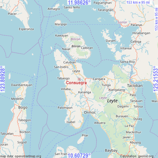
Consuegra GPS coordinates[2]
11° 17' 51.36" North, 124° 30' 44.64" East
| Map corner | latitude | longitude |
|---|---|---|
| Upper-left | 11.98626°, | 123.80928° |
| Center: | 11.2976°, | 124.5124° |
| Lower-right: | 10.60729°, | 125.21553° |
| Map W x H: | 153.3×153.3 km | = 95.3×95.3mi |
| max Lat: | 20.78733° ⇑53.3% North |
| Consuegra: | 11.2976° |
| min Lat: | ⇓46.7% South 4.65442° |
| min Long | Consuegra | max Long |
| 117.04868° | 124.5124° | 126.58417° |
| W 79%⇐ | ⇒21% E |
Elevation
Elevation of Consuegra is 9 m = 30 ft, and this is 78.9 m = 259 ft below average elevation for this country.
| Max E: |
2262 m = 7421 ft | 80.7% |
| Avg. | 87.9 m = 288 ft | |
| Consuegra | 9 m = 30 ft | |
Min E: |
-2 m = -7 ft | 19.3% |
See also: Philippines elevation on elevation.city.
Geographical zone
Consuegra is located in North Torrid zone (between Equator and Tropic of Cancer). Distance of Equator is 1256.2 km =780.6 mi to South.| Distance of | km | miles | from Consuegra |
|---|---|---|---|
| North Pole | 8750.9 | 5437.6 | to North |
| Arctic Circle | 6145 | 3818.3 | to North |
| Tropic Cancer | 1349.7 | 838.7 | to North |
| Equator | 1256.2 | 780.6 | to South |


Nearby cities:
15 places around Consuegra: (largest is in red/bold)
• Butazon
5.6 km =3.5 mi,  280°
280°
• Capoocan
14.1 km =8.8 mi,  91°
91°
• Culasian
10.8 km =6.7 mi,  84°
84°
• Ginabuyan
13.5 km =8.4 mi,  240°
240°
• Inangatan
13.4 km =8.3 mi,  246°
246°
• Kampokpok
11.7 km =7.3 mi,  269°
269°
• Kananya
13.4 km =8.3 mi,  157°
157°
• Leyte
8.4 km =5.2 mi,  336°
336°
• Limon
6 km =3.7 mi,  99°
99°
• Palaroo
12.4 km =7.7 mi,  345°
345°
• Pinamopoan
7 km =4.3 mi,  74°
74°
• Rizal
15.3 km =9.5 mi,  151°
151°
• Tabango
15.2 km =9.4 mi, 274°
• Umaganhan
15.2 km =9.4 mi, 283°
• Villaba
16.1 km =10 mi,  234°
234°
Sources, notices
• [Note1] Compared only with cities in Philippines existing in our database
• [Src1] Map data: © OpenStreetMap contributors (CC-BY-SA)
• [Src2] Other city data from geonames.org with taken over terms of usage.
• [Src3] Geographical zone / Annual Mean Temperature by Robert A. Rohde @ Wikipedia
