Naghalin geodata
Naghalin (Eastern Visayas) is a populated place; located in Philippines in Asia/Manila (GMT+8) time zone. With population of 2,977 people, there are 2557 cities with bigger population in this country. Compared to other cities in Philippines, 55.2% of cities are located further ↑North; 80.1% of cities are located further ←West and 63.6% of cities have lower elevation than Naghalin. Note1


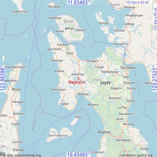
Naghalin GPS coordinates[2]
11° 8' 44.16" North, 124° 34' 1.56" East
| Map corner | latitude | longitude |
|---|---|---|
| Upper-left | 11.83463°, | 123.86398° |
| Center: | 11.1456°, | 124.5671° |
| Lower-right: | 10.45493°, | 125.27023° |
| Map W x H: | 153.4×153.4 km | = 95.3×95.3mi |
| max Lat: | 20.78733° ⇑55.2% North |
| Naghalin: | 11.1456° |
| min Lat: | ⇓44.8% South 4.65442° |
| min Long | Naghalin | max Long |
| 117.04868° | 124.5671° | 126.58417° |
| W 80.1%⇐ | ⇒19.9% E |
Elevation
Elevation of Naghalin is 39 m = 128 ft, and this is 48.9 m = 160 ft below average elevation for this country.
| Max E: |
2262 m = 7421 ft | 36.4% |
| Avg. | 87.9 m = 288 ft | |
| Naghalin | 39 m = 128 ft | |
Min E: |
-2 m = -7 ft | 63.6% |
See also: Philippines elevation on elevation.city.
Geographical zone
Naghalin is located in North Torrid zone (between Equator and Tropic of Cancer). Distance of Equator is 1239.3 km =770.1 mi to South.| Distance of | km | miles | from Naghalin |
|---|---|---|---|
| North Pole | 8767.8 | 5448.1 | to North |
| Arctic Circle | 6161.9 | 3828.8 | to North |
| Tropic Cancer | 1366.6 | 849.2 | to North |
| Equator | 1239.3 | 770.1 | to South |


Nearby cities:
15 places around Naghalin: (largest is in red/bold)
• Balagtas
5.4 km =3.4 mi,  255°
255°
• Dolores
10.6 km =6.6 mi,  151°
151°
• Kananya
4.6 km =2.9 mi,  350°
350°
• Lao
14.2 km =8.8 mi,  183°
183°
• Libertad
12.1 km =7.5 mi, 179°
• Liloan
11.4 km =7.1 mi,  189°
189°
• Lim-oo
7 km =4.3 mi,  85°
85°
• Malilinao
8.4 km =5.2 mi,  239°
239°
• Margen
14.9 km =9.3 mi,  196°
196°
• Masarayao
8.3 km =5.2 mi,  138°
138°
• Rizal
3.7 km =2.3 mi,  21°
21°
• San Vicente
3 km =1.9 mi, 182°
• Santo Niño
9.2 km =5.7 mi, 183°
• Tugbong
14.8 km =9.2 mi,  165°
165°
• Valencia
4.1 km =2.5 mi, 171°
Sources, notices
• [Note1] Compared only with cities in Philippines existing in our database
• [Src1] Map data: © OpenStreetMap contributors (CC-BY-SA)
• [Src2] Other city data from geonames.org with taken over terms of usage.
• [Src3] Geographical zone / Annual Mean Temperature by Robert A. Rohde @ Wikipedia
