Leyte geodata
Leyte (Eastern Visayas) is a seat of a third-order administrative division; located in Philippines in Asia/Manila (GMT+8) time zone. With population of 7,223 people, there are 870 cities with bigger population in this country. Compared to other cities in Philippines, 52.7% of cities are located further ↑North; 78.7% of cities are located further ←West and 99.6% of cities have higher elevation than Leyte. Note1


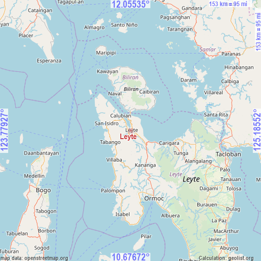
Leyte GPS coordinates[2]
11° 22' 0.732" North, 124° 28' 56.604" East
| Map corner | latitude | longitude |
|---|---|---|
| Upper-left | 12.05535°, | 123.77927° |
| Center: | 11.36687°, | 124.48239° |
| Lower-right: | 10.67672°, | 125.18552° |
| Map W x H: | 153.3×153.3 km | = 95.3×95.3mi |
| max Lat: | 20.78733° ⇑52.7% North |
| Leyte: | 11.36687° |
| min Lat: | ⇓47.3% South 4.65442° |
| min Long | Leyte | max Long |
| 117.04868° | 124.48239° | 126.58417° |
| W 78.7%⇐ | ⇒21.3% E |
Elevation
Elevation of Leyte is 1 m = 3 ft, and this is 86.9 m = 285 ft below average elevation for this country.
| Max E: |
2262 m = 7421 ft | 99.6% |
| Avg. | 87.9 m = 288 ft | |
| Leyte | 1 m = 3 ft | |
Min E: |
-2 m = -7 ft | 0.4% |
See also: Philippines elevation on elevation.city.
Geographical zone
Leyte is located in North Torrid zone (between Equator and Tropic of Cancer). Distance of Equator is 1263.9 km =785.4 mi to South.| Distance of | km | miles | from Leyte |
|---|---|---|---|
| North Pole | 8743.2 | 5432.8 | to North |
| Arctic Circle | 6137.3 | 3813.5 | to North |
| Tropic Cancer | 1342 | 833.9 | to North |
| Equator | 1263.9 | 785.4 | to South |


Nearby cities:
15 places around Leyte: (largest is in red/bold)
• Balagui
13.2 km =8.2 mi,  24°
24°
• Basud
13 km =8.1 mi,  269°
269°
• Biliran
11.2 km =7 mi,  355°
355°
• Butazon
7 km =4.3 mi,  198°
198°
• Calubian
10.7 km =6.6 mi,  326°
326°
• Consuegra
8.4 km =5.2 mi,  156°
156°
• Kampokpok
11.5 km =7.1 mi,  227°
227°
• Limon
12.7 km =7.9 mi,  133°
133°
• Looc
14.7 km =9.1 mi,  32°
32°
• Palaroo
4.3 km =2.7 mi,  0°
0°
• Pinamopoan
11.5 km =7.1 mi,  120°
120°
• San Isidro
14.9 km =9.3 mi,  287°
287°
• Tabango
13.6 km =8.5 mi,  241°
241°
• Tabing
14.9 km =9.3 mi,  284°
284°
• Umaganhan
12.2 km =7.6 mi,  249°
249°
Sources, notices
• [Note1] Compared only with cities in Philippines existing in our database
• [Src1] Map data: © OpenStreetMap contributors (CC-BY-SA)
• [Src2] Other city data from geonames.org with taken over terms of usage.
• [Src3] Geographical zone / Annual Mean Temperature by Robert A. Rohde @ Wikipedia
