Malilinao geodata
Malilinao (Eastern Visayas) is a populated place; located in Philippines in Asia/Manila (GMT+8) time zone. With population of 2,397 people, there are 3467 cities with bigger population in this country. Compared to other cities in Philippines, 55.7% of cities are located further ↑North; 78.9% of cities are located further ←West and 56.1% of cities have higher elevation than Malilinao. Note1


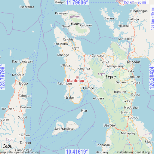
Malilinao GPS coordinates[2]
11° 6' 24.984" North, 124° 30' 3.996" East
| Map corner | latitude | longitude |
|---|---|---|
| Upper-left | 11.79606°, | 123.79799° |
| Center: | 11.10694°, | 124.50111° |
| Lower-right: | 10.41619°, | 125.20424° |
| Map W x H: | 153.4×153.4 km | = 95.3×95.3mi |
| max Lat: | 20.78733° ⇑55.7% North |
| Malilinao: | 11.10694° |
| min Lat: | ⇓44.3% South 4.65442° |
| min Long | Malilinao | max Long |
| 117.04868° | 124.50111° | 126.58417° |
| W 78.9%⇐ | ⇒21.1% E |
Elevation
Elevation of Malilinao is 19 m = 62 ft, and this is 68.9 m = 226 ft below average elevation for this country.
| Max E: |
2262 m = 7421 ft | 56.1% |
| Avg. | 87.9 m = 288 ft | |
| Malilinao | 19 m = 62 ft | |
Min E: |
-2 m = -7 ft | 43.9% |
See also: Philippines elevation on elevation.city.
Geographical zone
Malilinao is located in North Torrid zone (between Equator and Tropic of Cancer). Distance of Equator is 1235 km =767.4 mi to South.| Distance of | km | miles | from Malilinao |
|---|---|---|---|
| North Pole | 8772.1 | 5450.7 | to North |
| Arctic Circle | 6166.2 | 3831.5 | to North |
| Tropic Cancer | 1370.9 | 851.8 | to North |
| Equator | 1235 | 767.4 | to South |


Nearby cities:
15 places around Malilinao: (largest is in red/bold)
• Balagtas
3.5 km =2.2 mi,  33°
33°
• Dolores
13.3 km =8.3 mi,  112°
112°
• Kananya
11 km =6.8 mi,  35°
35°
• Lao
11.8 km =7.3 mi,  147°
147°
• Libertad
10.7 km =6.6 mi,  136°
136°
• Liloan
8.8 km =5.5 mi, 142°
• Margen
10.4 km =6.5 mi,  163°
163°
• Masarayao
12.8 km =8 mi,  98°
98°
• Naghalin
8.4 km =5.2 mi,  59°
59°
• Rizal
11.5 km =7.1 mi,  47°
47°
• San Juan
12.5 km =7.8 mi, 160°
• San Vicente
7.2 km =4.5 mi,  79°
79°
• Santo Niño
8.2 km =5.1 mi,  126°
126°
• Tagbubungang Diot
10.9 km =6.8 mi,  281°
281°
• Valencia
7.8 km =4.8 mi,  88°
88°
Sources, notices
• [Note1] Compared only with cities in Philippines existing in our database
• [Src1] Map data: © OpenStreetMap contributors (CC-BY-SA)
• [Src2] Other city data from geonames.org with taken over terms of usage.
• [Src3] Geographical zone / Annual Mean Temperature by Robert A. Rohde @ Wikipedia
