Capitan Ramon geodata
Capitan Ramon (Western Visayas) is a populated place; located in Philippines in Asia/Manila (GMT+8) time zone. With population of 4,640 people, there are 1434 cities with bigger population in this country. Compared to other cities in Philippines, 60.1% of cities are located further ↑North; 55.2% of cities are located further ←West and 88.7% of cities have lower elevation than Capitan Ramon. Note1
Administrative division(s):
- Level 1: Western Visayas
- Level 2: Province of Negros Occidental
- Level 3: Silay City


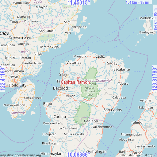
Capitan Ramon GPS coordinates[2]
10° 45' 36.72" North, 123° 6' 53.28" East
| Map corner | latitude | longitude |
|---|---|---|
| Upper-left | 11.45015°, | 122.41168° |
| Center: | 10.7602°, | 123.1148° |
| Lower-right: | 10.06866°, | 123.81793° |
| Map W x H: | 153.6×153.6 km | = 95.4×95.4mi |
| max Lat: | 20.78733° ⇑60.1% North |
| Capitan Ramon: | 10.7602° |
| min Lat: | ⇓39.9% South 4.65442° |
| min Long | Capitan Ramon | max Long |
| 117.04868° | 123.1148° | 126.58417° |
| W 55.2%⇐ | ⇒44.8% E |
Elevation
Elevation of Capitan Ramon is 197 m = 646 ft, and this is 109.1 m = 358 ft above average elevation for this country.
| Max E: |
2262 m = 7421 ft | 11.3% |
| Capitan Ramon | 197 m 646 ft | |
| Avg. | 87.9 m = 288 ft | |
Min E: |
-2 m = -7 ft | 88.7% |
See also: Philippines elevation on elevation.city.
Geographical zone
Capitan Ramon is located in North Torrid zone (between Equator and Tropic of Cancer). Distance of Equator is 1196.4 km =743.4 mi to South.| Distance of | km | miles | from Capitan Ramon |
|---|---|---|---|
| North Pole | 8810.6 | 5474.7 | to North |
| Arctic Circle | 6204.8 | 3855.5 | to North |
| Tropic Cancer | 1409.5 | 875.8 | to North |
| Equator | 1196.4 | 743.4 | to South |


Nearby cities:
15 places around Capitan Ramon: (largest is in red/bold)
• Alacaygan
10.8 km =6.7 mi,  325°
325°
• Alegria
13.4 km =8.3 mi,  194°
194°
• Binonga
14.6 km =9.1 mi,  275°
275°
• Buenavista
16.3 km =10.1 mi, 185°
• Concepcion
9.6 km =6 mi,  217°
217°
• Dos Hermanas
8.7 km =5.4 mi,  256°
256°
• Eustaquio Lopez
10.4 km =6.5 mi,  309°
309°
• Imbang
11 km =6.8 mi,  291°
291°
• Nangka
13.7 km =8.5 mi,  320°
320°
• San Fernando
7.5 km =4.7 mi, 220°
• Santa Cruz
14.5 km =9 mi, 194°
• Talisay
16.4 km =10.2 mi, 261°
• Tanza
14.1 km =8.8 mi, 306°
• Victorias
16.4 km =10.2 mi,  342°
342°
• Viejo Daan Banua
17 km =10.6 mi, 339°
Sources, notices
• [Note1] Compared only with cities in Philippines existing in our database
• [Src1] Map data: © OpenStreetMap contributors (CC-BY-SA)
• [Src2] Other city data from geonames.org with taken over terms of usage.
• [Src3] Geographical zone / Annual Mean Temperature by Robert A. Rohde @ Wikipedia
