Sibonga geodata
Sibonga (Central Visayas) is a seat of a third-order administrative division; located in Philippines in Asia/Manila (GMT+8) time zone. With population of 11,993 people, there are 520 cities with bigger population in this country. Compared to other cities in Philippines, 68.1% of cities are located further ↑North; 64.2% of cities are located further ←West and 73.2% of cities have higher elevation than Sibonga. Note1


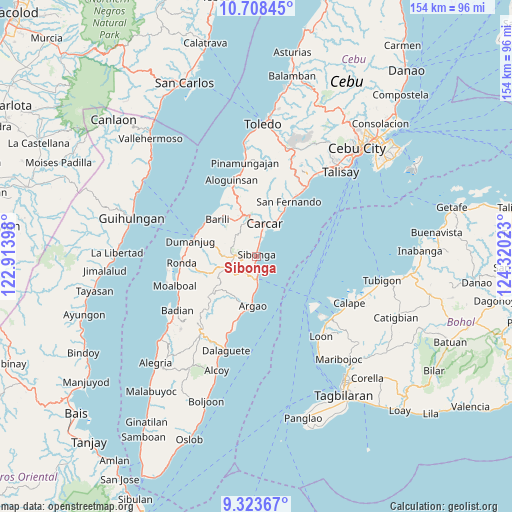
Sibonga GPS coordinates[2]
10° 1' 0.48" North, 123° 37' 1.56" East
| Map corner | latitude | longitude |
|---|---|---|
| Upper-left | 10.70845°, | 122.91398° |
| Center: | 10.0168°, | 123.6171° |
| Lower-right: | 9.32367°, | 124.32023° |
| Map W x H: | 154×154 km | = 95.7×95.7mi |
| max Lat: | 20.78733° ⇑68.1% North |
| Sibonga: | 10.0168° |
| min Lat: | ⇓31.9% South 4.65442° |
| min Long | Sibonga | max Long |
| 117.04868° | 123.6171° | 126.58417° |
| W 64.2%⇐ | ⇒35.8% E |
Elevation
Elevation of Sibonga is 11 m = 36 ft, and this is 76.9 m = 252 ft below average elevation for this country.
| Max E: |
2262 m = 7421 ft | 73.2% |
| Avg. | 87.9 m = 288 ft | |
| Sibonga | 11 m = 36 ft | |
Min E: |
-2 m = -7 ft | 26.8% |
See also: Philippines elevation on elevation.city.
Geographical zone
Sibonga is located in North Torrid zone (between Equator and Tropic of Cancer). Distance of Equator is 1113.8 km =692.1 mi to South.| Distance of | km | miles | from Sibonga |
|---|---|---|---|
| North Pole | 8893.3 | 5526 | to North |
| Arctic Circle | 6287.4 | 3906.8 | to North |
| Tropic Cancer | 1492.2 | 927.2 | to North |
| Equator | 1113.8 | 692.1 | to South |


Nearby cities:
15 places around Sibonga: (largest is in red/bold)
• Binlod
11 km =6.8 mi,  185°
185°
• Bulasa
9.4 km =5.8 mi,  179°
179°
• Calidñgan
9.4 km =5.8 mi,  10°
10°
• Can-asujan
13.3 km =8.3 mi,  19°
19°
• Carcar
10.2 km =6.3 mi, 14°
• Guadalupe
11.1 km =6.9 mi,  354°
354°
• Jampang
12.3 km =7.6 mi, 188°
• Langtad
14.1 km =8.8 mi, 185°
• Mantalongon
12.8 km =8 mi,  341°
341°
• Ocaña
5.5 km =3.4 mi, 8°
• Perrelos
12.7 km =7.9 mi,  29°
29°
• Simala
4.8 km =3 mi, 180°
• Tubod
5.4 km =3.4 mi,  244°
244°
• Tubod-dugoan
13.2 km =8.2 mi,  283°
283°
• Valencia
13.3 km =8.3 mi,  357°
357°
Sources, notices
• [Note1] Compared only with cities in Philippines existing in our database
• [Src1] Map data: © OpenStreetMap contributors (CC-BY-SA)
• [Src2] Other city data from geonames.org with taken over terms of usage.
• [Src3] Geographical zone / Annual Mean Temperature by Robert A. Rohde @ Wikipedia
