Tubay geodata
Tubay (Caraga) is a seat of a third-order administrative division; located in Philippines in Asia/Manila (GMT+8) time zone. With population of 7,946 people, there are 775 cities with bigger population in this country. Compared to other cities in Philippines, 74.8% of cities are located further ↑North; 93.8% of cities are located further ←West and 70.2% of cities have higher elevation than Tubay. Note1


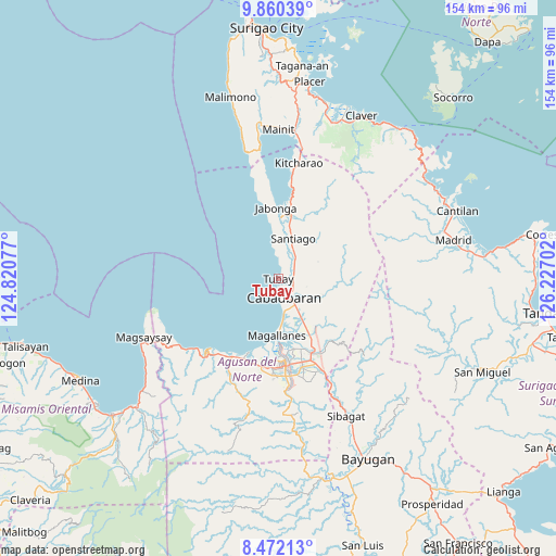
Tubay GPS coordinates[2]
9° 10' 0.984" North, 125° 31' 26.004" East
| Map corner | latitude | longitude |
|---|---|---|
| Upper-left | 9.86039°, | 124.82077° |
| Center: | 9.16694°, | 125.52389° |
| Lower-right: | 8.47213°, | 126.22702° |
| Map W x H: | 154.4×154.4 km | = 95.9×95.9mi |
| max Lat: | 20.78733° ⇑74.8% North |
| Tubay: | 9.16694° |
| min Lat: | ⇓25.2% South 4.65442° |
| min Long | Tubay | max Long |
| 117.04868° | 125.52389° | 126.58417° |
| W 93.8%⇐ | ⇒6.2% E |
Elevation
Elevation of Tubay is 12 m = 39 ft, and this is 75.9 m = 249 ft below average elevation for this country.
| Max E: |
2262 m = 7421 ft | 70.2% |
| Avg. | 87.9 m = 288 ft | |
| Tubay | 12 m = 39 ft | |
Min E: |
-2 m = -7 ft | 29.8% |
See also: Philippines elevation on elevation.city.
Geographical zone
Tubay is located in North Torrid zone (between Equator and Tropic of Cancer). Distance of Equator is 1019.3 km =633.4 mi to South.| Distance of | km | miles | from Tubay |
|---|---|---|---|
| North Pole | 8987.8 | 5584.8 | to North |
| Arctic Circle | 6381.9 | 3965.5 | to North |
| Tropic Cancer | 1586.7 | 985.9 | to North |
| Equator | 1019.3 | 633.4 | to South |


Nearby cities:
15 places around Tubay: (largest is in red/bold)
• Agay
14.4 km =8.9 mi,  151°
151°
• Balangbalang
16.4 km =10.2 mi,  138°
138°
• Bangonay
16.7 km =10.4 mi,  11°
11°
• Cabadbaran
5.1 km =3.2 mi,  165°
165°
• Calamba
10.4 km =6.5 mi,  132°
132°
• Caloc-an
13.4 km =8.3 mi,  176°
176°
• Comagascas
5 km =3.1 mi, 127°
• Del Pilar
6.9 km =4.3 mi,  104°
104°
• Jagupit
9.2 km =5.7 mi,  24°
24°
• La Union
9.1 km =5.7 mi, 171°
• Lombocan
17.8 km =11.1 mi,  186°
186°
• Los Angeles
19.5 km =12.1 mi, 151°
• Magallanes
16.4 km =10.2 mi, 182°
• Sanghan
10.5 km =6.5 mi, 149°
• Santa Ana
5.3 km =3.3 mi,  57°
57°
Sources, notices
• [Note1] Compared only with cities in Philippines existing in our database
• [Src1] Map data: © OpenStreetMap contributors (CC-BY-SA)
• [Src2] Other city data from geonames.org with taken over terms of usage.
• [Src3] Geographical zone / Annual Mean Temperature by Robert A. Rohde @ Wikipedia
