Agay geodata
Agay (Caraga) is a populated place; located in Philippines in Asia/Manila (GMT+8) time zone. With population of 3,976 people, there are 1743 cities with bigger population in this country. Compared to other cities in Philippines, 75.5% of cities are located further ↑North; 94.5% of cities are located further ←West and 65.1% of cities have higher elevation than Agay. Note1
Administrative division(s):
- Level 1: Caraga
- Level 2: Province of Agusan del Norte
- Level 3: Remedios T. Romualdez


Agay GPS coordinates[2]
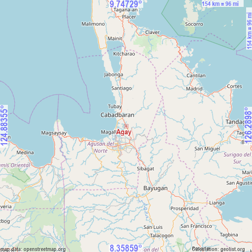
9° 3' 12.996" North, 125° 35' 12.012" East
| Map corner | latitude | longitude |
|---|---|---|
| Upper-left | 9.74729°, | 124.88355° |
| Center: | 9.05361°, | 125.58667° |
| Lower-right: | 8.35859°, | 126.2898° |
| Map W x H: | 154.4×154.4 km | = 95.9×95.9mi |
| max Lat: | 20.78733° ⇑75.5% North |
| Agay: | 9.05361° |
| min Lat: | ⇓24.5% South 4.65442° |
| min Long | Agay | max Long |
| 117.04868° | 125.58667° | 126.58417° |
| W 94.5%⇐ | ⇒5.5% E |
Elevation
Elevation of Agay is 14 m = 46 ft, and this is 73.9 m = 242 ft below average elevation for this country.
| Max E: |
2262 m = 7421 ft | 65.1% |
| Avg. | 87.9 m = 288 ft | |
| Agay | 14 m = 46 ft | |
Min E: |
-2 m = -7 ft | 34.9% |
See also: Philippines elevation on elevation.city.
Geographical zone
Agay is located in North Torrid zone (between Equator and Tropic of Cancer). Distance of Equator is 1006.7 km =625.5 mi to South.| Distance of | km | miles | from Agay |
|---|---|---|---|
| North Pole | 9000.4 | 5592.6 | to North |
| Arctic Circle | 6394.5 | 3973.4 | to North |
| Tropic Cancer | 1599.3 | 993.8 | to North |
| Equator | 1006.7 | 625.5 | to South |


Nearby cities:
15 places around Agay: (largest is in red/bold)
• Anticala
8.4 km =5.2 mi,  130°
130°
• Balangbalang
4 km =2.5 mi,  84°
84°
• Basag
14.8 km =9.2 mi,  164°
164°
• Butuan
12.5 km =7.8 mi,  202°
202°
• Cabadbaran
9.5 km =5.9 mi,  323°
323°
• Calamba
5.6 km =3.5 mi,  8°
8°
• Caloc-an
6.2 km =3.9 mi,  263°
263°
• Comagascas
10 km =6.2 mi,  342°
342°
• Del Pilar
10.9 km =6.8 mi,  358°
358°
• La Union
6.6 km =4.1 mi,  302°
302°
• Lombocan
10.3 km =6.4 mi,  240°
240°
• Los Angeles
5.1 km =3.2 mi,  152°
152°
• Magallanes
8.5 km =5.3 mi, 243°
• Sanghan
3.9 km =2.4 mi, 336°
• Tubay
14.4 km =8.9 mi,  331°
331°
Sources, notices
• [Note1] Compared only with cities in Philippines existing in our database
• [Src1] Map data: © OpenStreetMap contributors (CC-BY-SA)
• [Src2] Other city data from geonames.org with taken over terms of usage.
• [Src3] Geographical zone / Annual Mean Temperature by Robert A. Rohde @ Wikipedia
