Calamba geodata
Calamba (Caraga) is a populated place; located in Philippines in Asia/Manila (GMT+8) time zone. With population of 2,713 people, there are 2924 cities with bigger population in this country. Compared to other cities in Philippines, 75.2% of cities are located further ↑North; 94.5% of cities are located further ←West and 65.2% of cities have lower elevation than Calamba. Note1
Administrative division(s):
- Level 1: Caraga
- Level 2: Province of Agusan del Norte
- Level 3: City of Cabadbaran


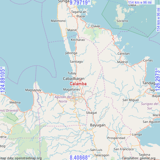
Calamba GPS coordinates[2]
9° 6' 12.996" North, 125° 35' 39.012" East
| Map corner | latitude | longitude |
|---|---|---|
| Upper-left | 9.79719°, | 124.89105° |
| Center: | 9.10361°, | 125.59417° |
| Lower-right: | 8.40868°, | 126.2973° |
| Map W x H: | 154.4×154.4 km | = 95.9×95.9mi |
| max Lat: | 20.78733° ⇑75.2% North |
| Calamba: | 9.10361° |
| min Lat: | ⇓24.8% South 4.65442° |
| min Long | Calamba | max Long |
| 117.04868° | 125.59417° | 126.58417° |
| W 94.5%⇐ | ⇒5.5% E |
Elevation
Elevation of Calamba is 42 m = 138 ft, and this is 45.9 m = 151 ft below average elevation for this country.
| Max E: |
2262 m = 7421 ft | 34.8% |
| Avg. | 87.9 m = 288 ft | |
| Calamba | 42 m = 138 ft | |
Min E: |
-2 m = -7 ft | 65.2% |
See also: Philippines elevation on elevation.city.
Geographical zone
Calamba is located in North Torrid zone (between Equator and Tropic of Cancer). Distance of Equator is 1012.2 km =629 mi to South.| Distance of | km | miles | from Calamba |
|---|---|---|---|
| North Pole | 8994.8 | 5589.1 | to North |
| Arctic Circle | 6388.9 | 3969.9 | to North |
| Tropic Cancer | 1593.7 | 990.3 | to North |
| Equator | 1012.2 | 629 | to South |


Nearby cities:
15 places around Calamba: (largest is in red/bold)
• Agay
5.6 km =3.5 mi,  188°
188°
• Anticala
12.4 km =7.7 mi,  153°
153°
• Balangbalang
6.1 km =3.8 mi, 148°
• Cabadbaran
6.8 km =4.2 mi,  288°
288°
• Caloc-an
9.4 km =5.8 mi,  227°
227°
• Comagascas
5.5 km =3.4 mi,  316°
316°
• Del Pilar
5.5 km =3.4 mi,  349°
349°
• Jagupit
15.9 km =9.9 mi, 345°
• La Union
6.7 km =4.2 mi,  252°
252°
• Lombocan
14.4 km =8.9 mi,  222°
222°
• Los Angeles
10.2 km =6.3 mi,  171°
171°
• Magallanes
12.6 km =7.8 mi, 222°
• Sanghan
3.1 km =1.9 mi, 229°
• Santa Ana
10.4 km =6.5 mi,  341°
341°
• Tubay
10.4 km =6.5 mi,  312°
312°
Sources, notices
• [Note1] Compared only with cities in Philippines existing in our database
• [Src1] Map data: © OpenStreetMap contributors (CC-BY-SA)
• [Src2] Other city data from geonames.org with taken over terms of usage.
• [Src3] Geographical zone / Annual Mean Temperature by Robert A. Rohde @ Wikipedia
