Balangbalang geodata
Balangbalang (Caraga) is a populated place; located in Philippines in Asia/Manila (GMT+8) time zone. With population of 2,135 people, there are 4023 cities with bigger population in this country. Compared to other cities in Philippines, 75.5% of cities are located further ↑North; 94.8% of cities are located further ←West and 65.9% of cities have lower elevation than Balangbalang. Note1
Administrative division(s):
- Level 1: Caraga
- Level 2: Province of Agusan del Norte
- Level 3: Remedios T. Romualdez


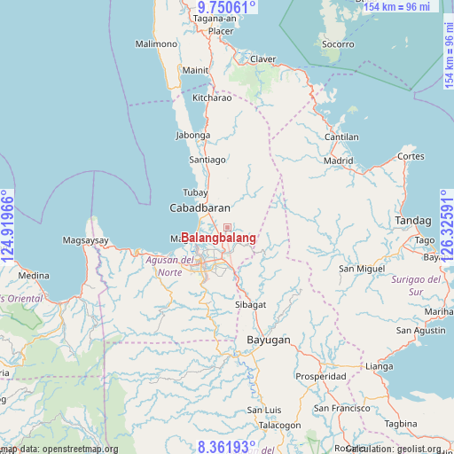
Balangbalang GPS coordinates[2]
9° 3' 24.984" North, 125° 37' 22.008" East
| Map corner | latitude | longitude |
|---|---|---|
| Upper-left | 9.75061°, | 124.91966° |
| Center: | 9.05694°, | 125.62278° |
| Lower-right: | 8.36193°, | 126.32591° |
| Map W x H: | 154.4×154.4 km | = 95.9×95.9mi |
| max Lat: | 20.78733° ⇑75.5% North |
| Balangbalang: | 9.05694° |
| min Lat: | ⇓24.5% South 4.65442° |
| min Long | Balangbalang | max Long |
| 117.04868° | 125.62278° | 126.58417° |
| W 94.8%⇐ | ⇒5.2% E |
Elevation
Elevation of Balangbalang is 43 m = 141 ft, and this is 44.9 m = 147 ft below average elevation for this country.
| Max E: |
2262 m = 7421 ft | 34.1% |
| Avg. | 87.9 m = 288 ft | |
| Balangbalang | 43 m = 141 ft | |
Min E: |
-2 m = -7 ft | 65.9% |
See also: Philippines elevation on elevation.city.
Geographical zone
Balangbalang is located in North Torrid zone (between Equator and Tropic of Cancer). Distance of Equator is 1007 km =625.7 mi to South.| Distance of | km | miles | from Balangbalang |
|---|---|---|---|
| North Pole | 9000 | 5592.3 | to North |
| Arctic Circle | 6394.1 | 3973.1 | to North |
| Tropic Cancer | 1598.9 | 993.5 | to North |
| Equator | 1007 | 625.7 | to South |


Nearby cities:
15 places around Balangbalang: (largest is in red/bold)
• Agay
4 km =2.5 mi,  264°
264°
• Anticala
6.3 km =3.9 mi,  157°
157°
• Basag
14.6 km =9.1 mi,  180°
180°
• Butuan
14.8 km =9.2 mi,  215°
215°
• Cabadbaran
12 km =7.5 mi,  307°
307°
• Calamba
6.1 km =3.8 mi,  328°
328°
• Caloc-an
10.2 km =6.3 mi, 263°
• Comagascas
11.5 km =7.1 mi,  323°
323°
• Del Pilar
11.4 km =7.1 mi,  338°
338°
• La Union
10.1 km =6.3 mi,  288°
288°
• Lombocan
14 km =8.7 mi,  246°
246°
• Los Angeles
5.2 km =3.2 mi,  198°
198°
• Magallanes
12.3 km =7.6 mi, 250°
• Sanghan
6.3 km =3.9 mi,  300°
300°
• Tubay
16.4 km =10.2 mi, 318°
Sources, notices
• [Note1] Compared only with cities in Philippines existing in our database
• [Src1] Map data: © OpenStreetMap contributors (CC-BY-SA)
• [Src2] Other city data from geonames.org with taken over terms of usage.
• [Src3] Geographical zone / Annual Mean Temperature by Robert A. Rohde @ Wikipedia
