Malalag geodata
Malalag (Davao) is a populated place; located in Philippines in Asia/Manila (GMT+8) time zone. With population of 6,180 people, there are 1010 cities with bigger population in this country. Compared to other cities in Philippines, 95% of cities are located further ↑North; 92.1% of cities are located further ←West and 67.4% of cities have higher elevation than Malalag. Note1


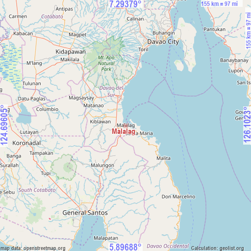
Malalag GPS coordinates[2]
6° 35' 44.988" North, 125° 23' 57.012" East
| Map corner | latitude | longitude |
|---|---|---|
| Upper-left | 7.29379°, | 124.69605° |
| Center: | 6.59583°, | 125.39917° |
| Lower-right: | 5.89688°, | 126.1023° |
| Map W x H: | 155.3×155.3 km | = 96.5×96.5mi |
| max Lat: | 20.78733° ⇑95% North |
| Malalag: | 6.59583° |
| min Lat: | ⇓5% South 4.65442° |
| min Long | Malalag | max Long |
| 117.04868° | 125.39917° | 126.58417° |
| W 92.1%⇐ | ⇒7.9% E |
Elevation
Elevation of Malalag is 13 m = 43 ft, and this is 74.9 m = 246 ft below average elevation for this country.
| Max E: |
2262 m = 7421 ft | 67.4% |
| Avg. | 87.9 m = 288 ft | |
| Malalag | 13 m = 43 ft | |
Min E: |
-2 m = -7 ft | 32.6% |
See also: Philippines elevation on elevation.city.
Geographical zone
Malalag is located in North Torrid zone (between Equator and Tropic of Cancer). Distance of Equator is 733.4 km =455.7 mi to South.| Distance of | km | miles | from Malalag |
|---|---|---|---|
| North Pole | 9273.7 | 5762.4 | to North |
| Arctic Circle | 6667.8 | 4143.2 | to North |
| Tropic Cancer | 1872.5 | 1163.5 | to North |
| Equator | 733.4 | 455.7 | to South |


Nearby cities:
15 places around Malalag: (largest is in red/bold)
• Balutakay
14.9 km =9.3 mi,  339°
339°
• Basiawan
11.9 km =7.4 mi,  125°
125°
• Bulacan
4 km =2.5 mi,  142°
142°
• Digos
17.7 km =11 mi, 344°
• Guihing Proper
11.1 km =6.9 mi,  332°
332°
• Hagonoy
12.7 km =7.9 mi,  320°
320°
• Ignit
16.6 km =10.3 mi,  314°
314°
• Malinao
14.3 km =8.9 mi,  299°
299°
• New Baclayon
3.5 km =2.2 mi,  248°
248°
• Padada
7.8 km =4.8 mi, 310°
• Pung-Pang
13 km =8.1 mi,  147°
147°
• Santa Maria
9.2 km =5.7 mi,  120°
120°
• Sinayawan
16.3 km =10.1 mi, 322°
• Sulop
6.1 km =3.8 mi,  272°
272°
• Tanlad
5.1 km =3.2 mi,  82°
82°
Sources, notices
• [Note1] Compared only with cities in Philippines existing in our database
• [Src1] Map data: © OpenStreetMap contributors (CC-BY-SA)
• [Src2] Other city data from geonames.org with taken over terms of usage.
• [Src3] Geographical zone / Annual Mean Temperature by Robert A. Rohde @ Wikipedia
