Maribojoc geodata
Maribojoc (Central Visayas) is a seat of a third-order administrative division; located in Philippines in Asia/Manila (GMT+8) time zone. With population of 2,476 people, there are 3337 cities with bigger population in this country. Compared to other cities in Philippines, 71.1% of cities are located further ↑North; 68.6% of cities are located further ←West and 76.6% of cities have higher elevation than Maribojoc. Note1


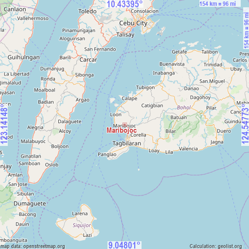
Maribojoc GPS coordinates[2]
9° 44' 30.12" North, 123° 50' 40.56" East
| Map corner | latitude | longitude |
|---|---|---|
| Upper-left | 10.43395°, | 123.14148° |
| Center: | 9.7417°, | 123.8446° |
| Lower-right: | 9.04801°, | 124.54773° |
| Map W x H: | 154.1×154.1 km | = 95.8×95.8mi |
| max Lat: | 20.78733° ⇑71.1% North |
| Maribojoc: | 9.7417° |
| min Lat: | ⇓28.9% South 4.65442° |
| min Long | Maribojoc | max Long |
| 117.04868° | 123.8446° | 126.58417° |
| W 68.6%⇐ | ⇒31.4% E |
Elevation
Elevation of Maribojoc is 10 m = 33 ft, and this is 77.9 m = 256 ft below average elevation for this country.
| Max E: |
2262 m = 7421 ft | 76.6% |
| Avg. | 87.9 m = 288 ft | |
| Maribojoc | 10 m = 33 ft | |
Min E: |
-2 m = -7 ft | 23.4% |
See also: Philippines elevation on elevation.city.
Geographical zone
Maribojoc is located in North Torrid zone (between Equator and Tropic of Cancer). Distance of Equator is 1083.2 km =673.1 mi to South.| Distance of | km | miles | from Maribojoc |
|---|---|---|---|
| North Pole | 8923.9 | 5545.1 | to North |
| Arctic Circle | 6318 | 3925.8 | to North |
| Tropic Cancer | 1522.7 | 946.2 | to North |
| Equator | 1083.2 | 673.1 | to South |


Nearby cities:
15 places around Maribojoc: (largest is in red/bold)
• Antequera
7.4 km =4.6 mi,  53°
53°
• Baclayon
13.9 km =8.6 mi,  157°
157°
• Balilihan
14.2 km =8.8 mi,  83°
83°
• Bood
1.9 km =1.2 mi,  281°
281°
• Corella
10.4 km =6.5 mi,  125°
125°
• Cortes
4.5 km =2.8 mi,  119°
119°
• Dauis
13.2 km =8.2 mi,  169°
169°
• De la Paz
5.1 km =3.2 mi,  154°
154°
• Loon
8.6 km =5.3 mi,  318°
318°
• San Agustin
13.8 km =8.6 mi,  209°
209°
• Sikatuna
15.5 km =9.6 mi,  112°
112°
• Songculan
12.6 km =7.8 mi,  187°
187°
• Tabalong
13.8 km =8.6 mi, 194°
• Tagbilaran City
9.6 km =6 mi,  175°
175°
• Totolan
12.1 km =7.5 mi, 178°
Sources, notices
• [Note1] Compared only with cities in Philippines existing in our database
• [Src1] Map data: © OpenStreetMap contributors (CC-BY-SA)
• [Src2] Other city data from geonames.org with taken over terms of usage.
• [Src3] Geographical zone / Annual Mean Temperature by Robert A. Rohde @ Wikipedia
