Corella geodata
Corella (Central Visayas) is a seat of a third-order administrative division; located in Philippines in Asia/Manila (GMT+8) time zone. In our database, there are 4166 cities with bigger population. Compared to other cities in Philippines, 71.7% of cities are located further ↑North; 69.6% of cities are located further ←West and 75.3% of cities have lower elevation than Corella. Note1


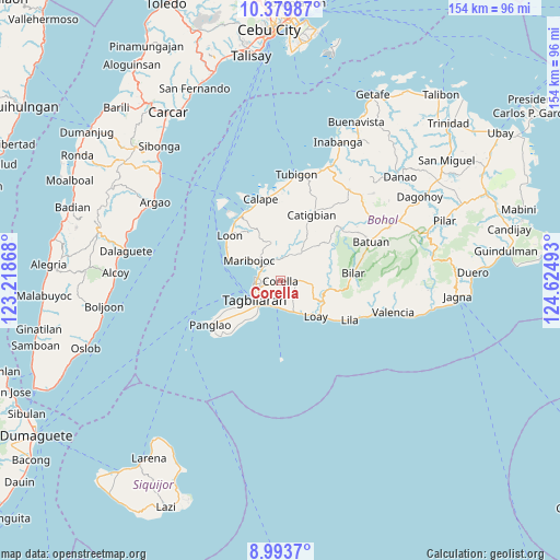
Corella GPS coordinates[2]
9° 41' 15" North, 123° 55' 18.48" East
| Map corner | latitude | longitude |
|---|---|---|
| Upper-left | 10.37987°, | 123.21868° |
| Center: | 9.6875°, | 123.9218° |
| Lower-right: | 8.9937°, | 124.62493° |
| Map W x H: | 154.1×154.1 km | = 95.8×95.8mi |
| max Lat: | 20.78733° ⇑71.7% North |
| Corella: | 9.6875° |
| min Lat: | ⇓28.3% South 4.65442° |
| min Long | Corella | max Long |
| 117.04868° | 123.9218° | 126.58417° |
| W 69.6%⇐ | ⇒30.4% E |
Elevation
Elevation of Corella is 69 m = 226 ft, and this is 18.9 m = 62 ft below average elevation for this country.
| Max E: |
2262 m = 7421 ft | 24.7% |
| Avg. | 87.9 m = 288 ft | |
| Corella | 69 m = 226 ft | |
Min E: |
-2 m = -7 ft | 75.3% |
See also: Philippines elevation on elevation.city.
Geographical zone
Corella is located in North Torrid zone (between Equator and Tropic of Cancer). Distance of Equator is 1077.1 km =669.3 mi to South.| Distance of | km | miles | from Corella |
|---|---|---|---|
| North Pole | 8929.9 | 5548.8 | to North |
| Arctic Circle | 6324 | 3929.6 | to North |
| Tropic Cancer | 1528.8 | 950 | to North |
| Equator | 1077.1 | 669.3 | to South |


Nearby cities:
15 places around Corella: (largest is in red/bold)
• Alburquerque
9.7 km =6 mi,  155°
155°
• Antequera
10.7 km =6.6 mi,  346°
346°
• Baclayon
7.4 km =4.6 mi,  204°
204°
• Balilihan
9.5 km =5.9 mi,  36°
36°
• Bood
12.1 km =7.5 mi,  301°
301°
• Catarman
11.6 km =7.2 mi,  214°
214°
• Cortes
6 km =3.7 mi,  309°
309°
• Dauis
9.2 km =5.7 mi,  221°
221°
• De la Paz
6.5 km =4 mi,  282°
282°
• Loboc
13.5 km =8.4 mi,  113°
113°
• Maribojoc
10.4 km =6.5 mi, 305°
• Sikatuna
5.8 km =3.6 mi,  89°
89°
• Songculan
12 km =7.5 mi,  237°
237°
• Tagbilaran City
8.4 km =5.2 mi,  245°
245°
• Totolan
10.2 km =6.3 mi,  233°
233°
Sources, notices
• [Note1] Compared only with cities in Philippines existing in our database
• [Src1] Map data: © OpenStreetMap contributors (CC-BY-SA)
• [Src2] Other city data from geonames.org with taken over terms of usage.
• [Src3] Geographical zone / Annual Mean Temperature by Robert A. Rohde @ Wikipedia
