Cortes geodata
Cortes (Central Visayas) is a seat of a third-order administrative division; located in Philippines in Asia/Manila (GMT+8) time zone. In our database, there are 4166 cities with bigger population. Compared to other cities in Philippines, 71.4% of cities are located further ↑North; 69.2% of cities are located further ←West and 66.7% of cities have lower elevation than Cortes. Note1


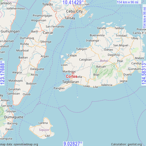
Cortes GPS coordinates[2]
9° 43' 19.2" North, 123° 52' 48" East
| Map corner | latitude | longitude |
|---|---|---|
| Upper-left | 10.41429°, | 123.17688° |
| Center: | 9.722°, | 123.88° |
| Lower-right: | 9.02827°, | 124.58313° |
| Map W x H: | 154.1×154.1 km | = 95.8×95.8mi |
| max Lat: | 20.78733° ⇑71.4% North |
| Cortes: | 9.722° |
| min Lat: | ⇓28.6% South 4.65442° |
| min Long | Cortes | max Long |
| 117.04868° | 123.88° | 126.58417° |
| W 69.2%⇐ | ⇒30.8% E |
Elevation
Elevation of Cortes is 45 m = 148 ft, and this is 42.9 m = 141 ft below average elevation for this country.
| Max E: |
2262 m = 7421 ft | 33.3% |
| Avg. | 87.9 m = 288 ft | |
| Cortes | 45 m = 148 ft | |
Min E: |
-2 m = -7 ft | 66.7% |
See also: Philippines elevation on elevation.city.
Geographical zone
Cortes is located in North Torrid zone (between Equator and Tropic of Cancer). Distance of Equator is 1081 km =671.7 mi to South.| Distance of | km | miles | from Cortes |
|---|---|---|---|
| North Pole | 8926.1 | 5546.4 | to North |
| Arctic Circle | 6320.2 | 3927.2 | to North |
| Tropic Cancer | 1524.9 | 947.5 | to North |
| Equator | 1081 | 671.7 | to South |


Nearby cities:
15 places around Cortes: (largest is in red/bold)
• Antequera
6.9 km =4.3 mi,  17°
17°
• Baclayon
10.7 km =6.6 mi,  171°
171°
• Balilihan
10.9 km =6.8 mi,  69°
69°
• Bood
6.3 km =3.9 mi,  294°
294°
• Catarman
13.5 km =8.4 mi,  188°
188°
• Corella
6 km =3.7 mi,  129°
129°
• Dauis
10.9 km =6.8 mi, 188°
• De la Paz
3 km =1.9 mi,  215°
215°
• Loon
12.9 km =8 mi,  312°
312°
• Maribojoc
4.5 km =2.8 mi,  299°
299°
• Sikatuna
11.1 km =6.9 mi,  109°
109°
• Songculan
11.7 km =7.3 mi,  208°
208°
• Tabalong
13.4 km =8.3 mi, 213°
• Tagbilaran City
8 km =5 mi,  202°
202°
• Totolan
10.6 km =6.6 mi, 200°
Sources, notices
• [Note1] Compared only with cities in Philippines existing in our database
• [Src1] Map data: © OpenStreetMap contributors (CC-BY-SA)
• [Src2] Other city data from geonames.org with taken over terms of usage.
• [Src3] Geographical zone / Annual Mean Temperature by Robert A. Rohde @ Wikipedia
