Aga geodata
Aga (Calabarzon) is a populated place; located in Philippines in Asia/Manila (GMT+8) time zone. With population of 5,218 people, there are 1224 cities with bigger population in this country. Compared to other cities in Philippines, 70.3% of cities are located further ↓South; 82.1% of cities are located further →East and 94% of cities have lower elevation than Aga. Note1


Aga GPS coordinates[2]
14° 5' 47.4" North, 120° 48' 7.812" East
| Map corner | latitude | longitude |
|---|---|---|
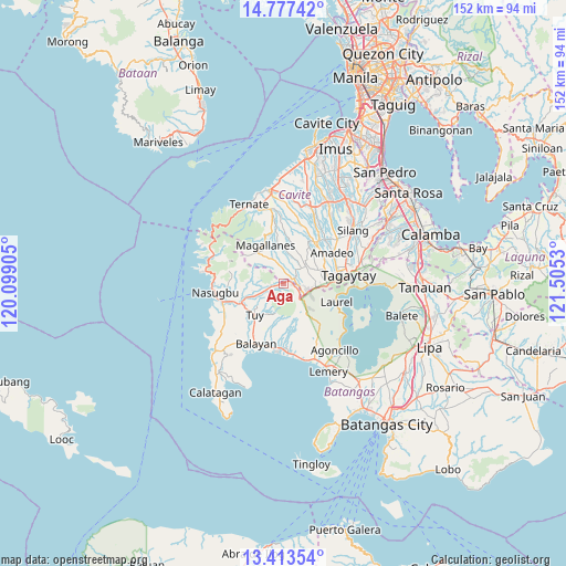
| Upper-left | 14.77742°, | 120.09905° |
| Center: | 14.0965°, | 120.80217° |
| Lower-right: | 13.41354°, | 121.5053° |
| Map W x H: | 151.6×151.7 km | = 94.2×94.3mi |
| max Lat: | 20.78733° ⇑29.7% North |
| Aga: | 14.0965° |
| min Lat: | ⇓70.3% South 4.65442° |
| min Long | Aga | max Long |
| 117.04868° | 120.80217° | 126.58417° |
| W 17.9%⇐ | ⇒82.1% E |
Elevation
Elevation of Aga is 368 m = 1207 ft, and this is 280.1 m = 919 ft above average elevation for this country.
| Max E: |
2262 m = 7421 ft | 6% |
| Aga | 368 m 1207 ft | |
| Avg. | 87.9 m = 288 ft | |
Min E: |
-2 m = -7 ft | 94% |
See also: Philippines elevation on elevation.city.
Geographical zone
Aga is located in North Torrid zone (between Equator and Tropic of Cancer). Distance of this Northern Tropic circle is 1038.5 km =645.3 mi to North.| Distance of | km | miles | from Aga |
|---|---|---|---|
| North Pole | 8439.7 | 5244.2 | to North |
| Arctic Circle | 5833.8 | 3625 | to North |
| Tropic Cancer | 1038.5 | 645.3 | to North |
| Equator | 1567.4 | 973.9 | to South |


Nearby cities:
15 places around Aga: (largest is in red/bold)
• Alfonso
7.4 km =4.6 mi,  48°
48°
• Anuling
10.2 km =6.3 mi,  72°
72°
• Banilad
8 km =5 mi,  245°
245°
• Bolboc
9.8 km =6.1 mi,  210°
210°
• General Emilio Aguinaldo
9.8 km =6.1 mi,  355°
355°
• Guyam Malaki
8.9 km =5.5 mi, 45°
• Kaytitinga
3.1 km =1.9 mi, 67°
• Luksuhin
8.5 km =5.3 mi,  89°
89°
• Mangas
7.3 km =4.5 mi, 71°
• Matagbak
5.2 km =3.2 mi,  42°
42°
• Mataywanac
10.7 km =6.6 mi,  227°
227°
• Sabang
10.5 km =6.5 mi, 249°
• Taywanak Ilaya
8.3 km =5.2 mi, 35°
• Toong
5.1 km =3.2 mi,  235°
235°
• Tumalim
8.7 km =5.4 mi,  257°
257°
Sources, notices
• [Note1] Compared only with cities in Philippines existing in our database
• [Src1] Map data: © OpenStreetMap contributors (CC-BY-SA)
• [Src2] Other city data from geonames.org with taken over terms of usage.
• [Src3] Geographical zone / Annual Mean Temperature by Robert A. Rohde @ Wikipedia
