Bolo geodata
Bolo (Western Visayas) is a populated place; located in Philippines in Asia/Manila (GMT+8) time zone. With population of 4,705 people, there are 1408 cities with bigger population in this country. Compared to other cities in Philippines, 50.9% of cities are located further ↑North; 50.7% of cities are located further →East and 57.6% of cities have higher elevation than Bolo. Note1


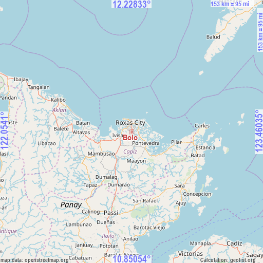
Bolo GPS coordinates[2]
11° 32' 25.008" North, 122° 45' 25.992" East
| Map corner | latitude | longitude |
|---|---|---|
| Upper-left | 12.22833°, | 122.0541° |
| Center: | 11.54028°, | 122.75722° |
| Lower-right: | 10.85054°, | 123.46035° |
| Map W x H: | 153.2×153.2 km | = 95.2×95.2mi |
| max Lat: | 20.78733° ⇑50.9% North |
| Bolo: | 11.54028° |
| min Lat: | ⇓49.1% South 4.65442° |
| min Long | Bolo | max Long |
| 117.04868° | 122.75722° | 126.58417° |
| W 49.3%⇐ | ⇒50.7% E |
Elevation
Elevation of Bolo is 18 m = 59 ft, and this is 69.9 m = 229 ft below average elevation for this country.
| Max E: |
2262 m = 7421 ft | 57.6% |
| Avg. | 87.9 m = 288 ft | |
| Bolo | 18 m = 59 ft | |
Min E: |
-2 m = -7 ft | 42.4% |
See also: Philippines elevation on elevation.city.
Geographical zone
Bolo is located in North Torrid zone (between Equator and Tropic of Cancer). Distance of Equator is 1283.2 km =797.3 mi to South.| Distance of | km | miles | from Bolo |
|---|---|---|---|
| North Pole | 8723.9 | 5420.8 | to North |
| Arctic Circle | 6118 | 3801.5 | to North |
| Tropic Cancer | 1322.8 | 821.9 | to North |
| Equator | 1283.2 | 797.3 | to South |


Nearby cities:
15 places around Bolo: (largest is in red/bold)
• Cogon
9.8 km =6.1 mi,  149°
149°
• Intampilan
6.7 km =4.2 mi,  192°
192°
• Ivisan
7.5 km =4.7 mi,  254°
254°
• Lanot
2.3 km =1.4 mi,  180°
180°
• Lono
4.2 km =2.6 mi,  225°
225°
• Malocloc
9.4 km =5.8 mi, 245°
• Panay
4.5 km =2.8 mi,  64°
64°
• Panitan
8.4 km =5.2 mi,  168°
168°
• Pawa
7 km =4.3 mi,  69°
69°
• Roxas City
5 km =3.1 mi,  352°
352°
• Sibaguan
5.1 km =3.2 mi,  292°
292°
• Tabuc Pontevedra
9.1 km =5.7 mi,  134°
134°
• Talon
8.6 km =5.3 mi,  284°
284°
• Tanza
5.5 km =3.4 mi,  31°
31°
• Timpas
7.3 km =4.5 mi,  201°
201°
Sources, notices
• [Note1] Compared only with cities in Philippines existing in our database
• [Src1] Map data: © OpenStreetMap contributors (CC-BY-SA)
• [Src2] Other city data from geonames.org with taken over terms of usage.
• [Src3] Geographical zone / Annual Mean Temperature by Robert A. Rohde @ Wikipedia
