Ivisan geodata
Ivisan (Western Visayas) is a seat of a third-order administrative division; located in Philippines in Asia/Manila (GMT+8) time zone. With population of 5,036 people, there are 1282 cities with bigger population in this country. Compared to other cities in Philippines, 51.2% of cities are located further ↑North; 51.5% of cities are located further →East and 80.7% of cities have higher elevation than Ivisan. Note1


Ivisan GPS coordinates[2]
11° 31' 18.012" North, 122° 41' 26.988" East
| Map corner | latitude | longitude |
|---|---|---|
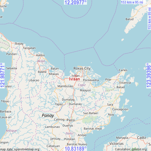
| Upper-left | 12.20977°, | 121.98771° |
| Center: | 11.52167°, | 122.69083° |
| Lower-right: | 10.83189°, | 123.39396° |
| Map W x H: | 153.2×153.2 km | = 95.2×95.2mi |
| max Lat: | 20.78733° ⇑51.2% North |
| Ivisan: | 11.52167° |
| min Lat: | ⇓48.8% South 4.65442° |
| min Long | Ivisan | max Long |
| 117.04868° | 122.69083° | 126.58417° |
| W 48.5%⇐ | ⇒51.5% E |
Elevation
Elevation of Ivisan is 9 m = 30 ft, and this is 78.9 m = 259 ft below average elevation for this country.
| Max E: |
2262 m = 7421 ft | 80.7% |
| Avg. | 87.9 m = 288 ft | |
| Ivisan | 9 m = 30 ft | |
Min E: |
-2 m = -7 ft | 19.3% |
See also: Philippines elevation on elevation.city.
Geographical zone
Ivisan is located in North Torrid zone (between Equator and Tropic of Cancer). Distance of Equator is 1281.1 km =796 mi to South.| Distance of | km | miles | from Ivisan |
|---|---|---|---|
| North Pole | 8726 | 5422.1 | to North |
| Arctic Circle | 6120.1 | 3802.9 | to North |
| Tropic Cancer | 1324.8 | 823.2 | to North |
| Equator | 1281.1 | 796 | to South |


Nearby cities:
15 places around Ivisan: (largest is in red/bold)
• Basiao
6.5 km =4 mi,  297°
297°
• Bolo
7.5 km =4.7 mi,  74°
74°
• Dapdapan
7.2 km =4.5 mi,  244°
244°
• Intampilan
7.3 km =4.5 mi,  128°
128°
• Lanot
7.2 km =4.5 mi,  92°
92°
• Lono
4.3 km =2.7 mi,  101°
101°
• Malocloc
2.2 km =1.4 mi,  217°
217°
• Mianay
5.7 km =3.5 mi,  168°
168°
• Panitan
10.8 km =6.7 mi,  124°
124°
• Parion
5.3 km =3.3 mi, 172°
• Roxas City
9.7 km =6 mi,  42°
42°
• Sapian
10.1 km =6.3 mi,  252°
252°
• Sibaguan
4.7 km =2.9 mi,  32°
32°
• Talon
4.4 km =2.7 mi,  346°
346°
• Timpas
6.6 km =4.1 mi,  136°
136°
Sources, notices
• [Note1] Compared only with cities in Philippines existing in our database
• [Src1] Map data: © OpenStreetMap contributors (CC-BY-SA)
• [Src2] Other city data from geonames.org with taken over terms of usage.
• [Src3] Geographical zone / Annual Mean Temperature by Robert A. Rohde @ Wikipedia
