Timonan geodata
Timonan (Zamboanga Peninsula) is a populated place; located in Philippines in Asia/Manila (GMT+8) time zone. With population of 2,727 people, there are 2900 cities with bigger population in this country. Compared to other cities in Philippines, 80.6% of cities are located further ↑North; 54.5% of cities are located further ←West and 54.4% of cities have lower elevation than Timonan. Note1
Administrative division(s):
- Level 1: Zamboanga Peninsula
- Level 2: Province of Zamboanga del Norte
- Level 3: Sindangan


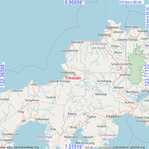
Timonan GPS coordinates[2]
8° 12' 42.12" North, 123° 4' 5.52" East
| Map corner | latitude | longitude |
|---|---|---|
| Upper-left | 8.90699°, | 122.36508° |
| Center: | 8.2117°, | 123.0682° |
| Lower-right: | 7.51519°, | 123.77133° |
| Map W x H: | 154.8×154.8 km | = 96.2×96.2mi |
| max Lat: | 20.78733° ⇑80.6% North |
| Timonan: | 8.2117° |
| min Lat: | ⇓19.4% South 4.65442° |
| min Long | Timonan | max Long |
| 117.04868° | 123.0682° | 126.58417° |
| W 54.5%⇐ | ⇒45.5% E |
Elevation
Elevation of Timonan is 27 m = 89 ft, and this is 60.9 m = 200 ft below average elevation for this country.
| Max E: |
2262 m = 7421 ft | 45.6% |
| Avg. | 87.9 m = 288 ft | |
| Timonan | 27 m = 89 ft | |
Min E: |
-2 m = -7 ft | 54.4% |
See also: Philippines elevation on elevation.city.
Geographical zone
Timonan is located in North Torrid zone (between Equator and Tropic of Cancer). Distance of Equator is 913.1 km =567.4 mi to South.| Distance of | km | miles | from Timonan |
|---|---|---|---|
| North Pole | 9094 | 5650.7 | to North |
| Arctic Circle | 6488.1 | 4031.5 | to North |
| Tropic Cancer | 1692.9 | 1051.9 | to North |
| Equator | 913.1 | 567.4 | to South |


Nearby cities:
15 places around Timonan: (largest is in red/bold)
• Balagon
29.6 km =18.4 mi,  140°
140°
• Caracal
26.3 km =16.3 mi,  249°
249°
• Dicayong
3.9 km =2.4 mi,  284°
284°
• Disod
7.9 km =4.9 mi,  314°
314°
• Dumingag
31.4 km =19.5 mi,  98°
98°
• Leon Postigo
16.3 km =10.1 mi, 247°
• Linay
34.7 km =21.6 mi,  11°
11°
• Mandih
6 km =3.7 mi,  266°
266°
• Manukan
35.9 km =22.3 mi, 5°
• Midsalip
32.1 km =19.9 mi, 137°
• Ponot
27.2 km =16.9 mi,  349°
349°
• Salug
33.2 km =20.6 mi, 251°
• Siari
15.3 km =9.5 mi,  324°
324°
• Siayan
7 km =4.3 mi,  29°
29°
• Sindangan
8.3 km =5.2 mi,  290°
290°
Sources, notices
• [Note1] Compared only with cities in Philippines existing in our database
• [Src1] Map data: © OpenStreetMap contributors (CC-BY-SA)
• [Src2] Other city data from geonames.org with taken over terms of usage.
• [Src3] Geographical zone / Annual Mean Temperature by Robert A. Rohde @ Wikipedia
