Disod geodata
Disod (Zamboanga Peninsula) is a populated place; located in Philippines in Asia/Manila (GMT+8) time zone. With population of 2,085 people, there are 4091 cities with bigger population in this country. Compared to other cities in Philippines, 80.3% of cities are located further ↑North; 53.5% of cities are located further ←West and 74.9% of cities have lower elevation than Disod. Note1
Administrative division(s):
- Level 1: Zamboanga Peninsula
- Level 2: Province of Zamboanga del Norte
- Level 3: Sindangan


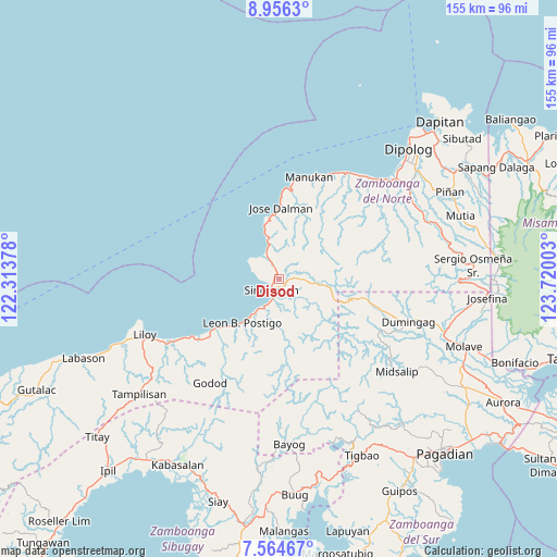
Disod GPS coordinates[2]
8° 15' 39.96" North, 123° 1' 0.84" East
| Map corner | latitude | longitude |
|---|---|---|
| Upper-left | 8.9563°, | 122.31378° |
| Center: | 8.2611°, | 123.0169° |
| Lower-right: | 7.56467°, | 123.72003° |
| Map W x H: | 154.7×154.7 km | = 96.1×96.1mi |
| max Lat: | 20.78733° ⇑80.3% North |
| Disod: | 8.2611° |
| min Lat: | ⇓19.7% South 4.65442° |
| min Long | Disod | max Long |
| 117.04868° | 123.0169° | 126.58417° |
| W 53.5%⇐ | ⇒46.5% E |
Elevation
Elevation of Disod is 68 m = 223 ft, and this is 19.9 m = 65 ft below average elevation for this country.
| Max E: |
2262 m = 7421 ft | 25.1% |
| Avg. | 87.9 m = 288 ft | |
| Disod | 68 m = 223 ft | |
Min E: |
-2 m = -7 ft | 74.9% |
See also: Philippines elevation on elevation.city.
Geographical zone
Disod is located in North Torrid zone (between Equator and Tropic of Cancer). Distance of Equator is 918.5 km =570.7 mi to South.| Distance of | km | miles | from Disod |
|---|---|---|---|
| North Pole | 9088.5 | 5647.3 | to North |
| Arctic Circle | 6482.6 | 4028.1 | to North |
| Tropic Cancer | 1687.4 | 1048.5 | to North |
| Equator | 918.5 | 570.7 | to South |


Nearby cities:
15 places around Disod: (largest is in red/bold)
• Caracal
24.1 km =15 mi,  231°
231°
• Dicayong
4.9 km =3 mi,  157°
157°
• Irasan
36.1 km =22.4 mi,  35°
35°
• Langatian
37.4 km =23.2 mi, 39°
• Leon Postigo
15.1 km =9.4 mi,  218°
218°
• Linay
31.2 km =19.4 mi,  24°
24°
• Mandih
5.8 km =3.6 mi,  183°
183°
• Manukan
31.6 km =19.6 mi, 16°
• Ponot
21.2 km =13.2 mi,  1°
1°
• Salug
30.4 km =18.9 mi,  237°
237°
• Seres
36.4 km =22.6 mi,  47°
47°
• Siari
7.7 km =4.8 mi,  335°
335°
• Siayan
9.2 km =5.7 mi,  86°
86°
• Sindangan
3.4 km =2.1 mi, 219°
• Timonan
7.9 km =4.9 mi,  134°
134°
Sources, notices
• [Note1] Compared only with cities in Philippines existing in our database
• [Src1] Map data: © OpenStreetMap contributors (CC-BY-SA)
• [Src2] Other city data from geonames.org with taken over terms of usage.
• [Src3] Geographical zone / Annual Mean Temperature by Robert A. Rohde @ Wikipedia
