Mandih geodata
Mandih (Zamboanga Peninsula) is a populated place; located in Philippines in Asia/Manila (GMT+8) time zone. With population of 3,420 people, there are 2123 cities with bigger population in this country. Compared to other cities in Philippines, 80.7% of cities are located further ↑North; 53.4% of cities are located further ←West and 70.2% of cities have higher elevation than Mandih. Note1
Administrative division(s):
- Level 1: Zamboanga Peninsula
- Level 2: Province of Zamboanga del Norte
- Level 3: Sindangan


Mandih GPS coordinates[2]
8° 12' 31.32" North, 123° 0' 50.76" East
| Map corner | latitude | longitude |
|---|---|---|
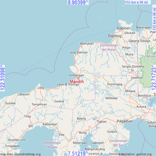
| Upper-left | 8.90399°, | 122.31098° |
| Center: | 8.2087°, | 123.0141° |
| Lower-right: | 7.51219°, | 123.71723° |
| Map W x H: | 154.8×154.8 km | = 96.2×96.2mi |
| max Lat: | 20.78733° ⇑80.7% North |
| Mandih: | 8.2087° |
| min Lat: | ⇓19.3% South 4.65442° |
| min Long | Mandih | max Long |
| 117.04868° | 123.0141° | 126.58417° |
| W 53.4%⇐ | ⇒46.6% E |
Elevation
Elevation of Mandih is 12 m = 39 ft, and this is 75.9 m = 249 ft below average elevation for this country.
| Max E: |
2262 m = 7421 ft | 70.2% |
| Avg. | 87.9 m = 288 ft | |
| Mandih | 12 m = 39 ft | |
Min E: |
-2 m = -7 ft | 29.8% |
See also: Philippines elevation on elevation.city.
Geographical zone
Mandih is located in North Torrid zone (between Equator and Tropic of Cancer). Distance of Equator is 912.7 km =567.1 mi to South.| Distance of | km | miles | from Mandih |
|---|---|---|---|
| North Pole | 9094.3 | 5650.9 | to North |
| Arctic Circle | 6488.5 | 4031.8 | to North |
| Tropic Cancer | 1693.2 | 1052.1 | to North |
| Equator | 912.7 | 567.1 | to South |


Nearby cities:
15 places around Mandih: (largest is in red/bold)
• Balagon
33.5 km =20.8 mi,  132°
132°
• Caracal
20.7 km =12.9 mi,  244°
244°
• Dicayong
2.5 km =1.6 mi,  58°
58°
• Disod
5.8 km =3.6 mi,  3°
3°
• Dumingag
37.3 km =23.2 mi,  96°
96°
• Leon Postigo
10.9 km =6.8 mi, 236°
• Linay
36.7 km =22.8 mi,  20°
20°
• Manukan
37.3 km =23.2 mi,  14°
14°
• Midsalip
36.2 km =22.5 mi, 129°
• Ponot
27.1 km =16.8 mi, 1°
• Salug
27.5 km =17.1 mi,  247°
247°
• Siari
13.2 km =8.2 mi,  347°
347°
• Siayan
11.4 km =7.1 mi, 55°
• Sindangan
3.7 km =2.3 mi,  330°
330°
• Timonan
6 km =3.7 mi,  86°
86°
Sources, notices
• [Note1] Compared only with cities in Philippines existing in our database
• [Src1] Map data: © OpenStreetMap contributors (CC-BY-SA)
• [Src2] Other city data from geonames.org with taken over terms of usage.
• [Src3] Geographical zone / Annual Mean Temperature by Robert A. Rohde @ Wikipedia
