Siayan geodata
Siayan (Zamboanga Peninsula) is a populated place; located in Philippines in Asia/Manila (GMT+8) time zone. With population of 4,906 people, there are 1337 cities with bigger population in this country. Compared to other cities in Philippines, 80.3% of cities are located further ↑North; 55% of cities are located further ←West and 72.4% of cities have lower elevation than Siayan. Note1
Administrative division(s):
- Level 1: Zamboanga Peninsula
- Level 2: Province of Zamboanga del Norte
- Level 3: Siayan


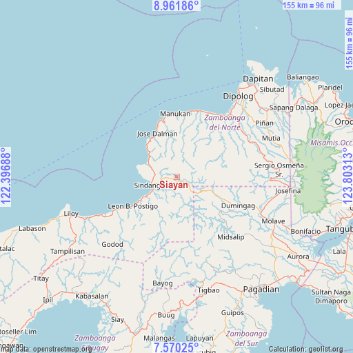
Siayan GPS coordinates[2]
8° 16' 0.012" North, 123° 6' 0" East
| Map corner | latitude | longitude |
|---|---|---|
| Upper-left | 8.96186°, | 122.39688° |
| Center: | 8.26667°, | 123.1° |
| Lower-right: | 7.57025°, | 123.80313° |
| Map W x H: | 154.7×154.7 km | = 96.1×96.1mi |
| max Lat: | 20.78733° ⇑80.3% North |
| Siayan: | 8.26667° |
| min Lat: | ⇓19.7% South 4.65442° |
| min Long | Siayan | max Long |
| 117.04868° | 123.1° | 126.58417° |
| W 55%⇐ | ⇒45% E |
Elevation
Elevation of Siayan is 59 m = 194 ft, and this is 28.9 m = 95 ft below average elevation for this country.
| Max E: |
2262 m = 7421 ft | 27.6% |
| Avg. | 87.9 m = 288 ft | |
| Siayan | 59 m = 194 ft | |
Min E: |
-2 m = -7 ft | 72.4% |
See also: Philippines elevation on elevation.city.
Geographical zone
Siayan is located in North Torrid zone (between Equator and Tropic of Cancer). Distance of Equator is 919.2 km =571.2 mi to South.| Distance of | km | miles | from Siayan |
|---|---|---|---|
| North Pole | 9087.9 | 5647 | to North |
| Arctic Circle | 6482 | 4027.7 | to North |
| Tropic Cancer | 1686.8 | 1048.1 | to North |
| Equator | 919.2 | 571.2 | to South |


Nearby cities:
15 places around Siayan: (largest is in red/bold)
• Caracal
32.1 km =19.9 mi,  241°
241°
• Dicayong
8.9 km =5.5 mi,  234°
234°
• Disod
9.2 km =5.7 mi,  266°
266°
• Dumingag
29.6 km =18.4 mi,  111°
111°
• Irasan
31.1 km =19.3 mi,  22°
22°
• Langatian
31.8 km =19.8 mi,  27°
27°
• Leon Postigo
22.3 km =13.9 mi, 236°
• Linay
28 km =17.4 mi,  7°
7°
• Mandih
11.4 km =7.1 mi, 235°
• Manukan
29.6 km =18.4 mi,  0°
0°
• Ponot
22.3 km =13.9 mi,  337°
337°
• Seres
29.8 km =18.5 mi,  37°
37°
• Siari
13.9 km =8.6 mi,  297°
297°
• Sindangan
11.7 km =7.3 mi,  254°
254°
• Timonan
7 km =4.3 mi,  209°
209°
Sources, notices
• [Note1] Compared only with cities in Philippines existing in our database
• [Src1] Map data: © OpenStreetMap contributors (CC-BY-SA)
• [Src2] Other city data from geonames.org with taken over terms of usage.
• [Src3] Geographical zone / Annual Mean Temperature by Robert A. Rohde @ Wikipedia
