Rizal geodata
Rizal (Western Visayas) is a populated place; located in Philippines in Asia/Manila (GMT+8) time zone. With population of 3,823 people, there are 1829 cities with bigger population in this country. Compared to other cities in Philippines, 58.4% of cities are located further ↑North; 60.7% of cities are located further ←West and 70% of cities have lower elevation than Rizal. Note1
Administrative division(s):
- Level 1: Western Visayas
- Level 2: Province of Negros Occidental
- Level 3: Sagay City


Rizal GPS coordinates[2]
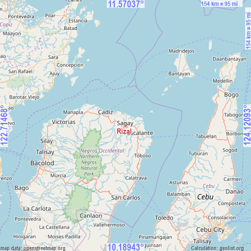
10° 52' 50.52" North, 123° 25' 4.08" East
| Map corner | latitude | longitude |
|---|---|---|
| Upper-left | 11.57037°, | 122.71468° |
| Center: | 10.8807°, | 123.4178° |
| Lower-right: | 10.18943°, | 124.12093° |
| Map W x H: | 153.5×153.5 km | = 95.4×95.4mi |
| max Lat: | 20.78733° ⇑58.4% North |
| Rizal: | 10.8807° |
| min Lat: | ⇓41.6% South 4.65442° |
| min Long | Rizal | max Long |
| 117.04868° | 123.4178° | 126.58417° |
| W 60.7%⇐ | ⇒39.3% E |
Elevation
Elevation of Rizal is 52 m = 171 ft, and this is 35.9 m = 118 ft below average elevation for this country.
| Max E: |
2262 m = 7421 ft | 30% |
| Avg. | 87.9 m = 288 ft | |
| Rizal | 52 m = 171 ft | |
Min E: |
-2 m = -7 ft | 70% |
See also: Philippines elevation on elevation.city.
Geographical zone
Rizal is located in North Torrid zone (between Equator and Tropic of Cancer). Distance of Equator is 1209.8 km =751.7 mi to South.| Distance of | km | miles | from Rizal |
|---|---|---|---|
| North Pole | 8797.2 | 5466.3 | to North |
| Arctic Circle | 6191.4 | 3847.2 | to North |
| Tropic Cancer | 1396.1 | 867.5 | to North |
| Equator | 1209.8 | 751.7 | to South |


Nearby cities:
15 places around Rizal: (largest is in red/bold)
• Bato
9.4 km =5.8 mi,  211°
211°
• Bolanon
7.3 km =4.5 mi,  56°
56°
• Cervantes
11.3 km =7 mi,  94°
94°
• Dian-ay
15.4 km =9.6 mi,  110°
110°
• Escalante
10 km =6.2 mi,  116°
116°
• Lañgub
15.7 km =9.8 mi,  126°
126°
• Lopez Jaena
3.7 km =2.3 mi,  186°
186°
• Mabini
11.9 km =7.4 mi,  142°
142°
• Maquiling
11.4 km =7.1 mi, 193°
• Paraiso
6 km =3.7 mi,  274°
274°
• Plaridel
8 km =5 mi,  76°
76°
• Sagay
7.2 km =4.5 mi,  5°
5°
• Tamlang
7.3 km =4.5 mi,  147°
147°
• Tiglauigan
10.4 km =6.5 mi,  320°
320°
• Vito
10.9 km =6.8 mi, 76°
Sources, notices
• [Note1] Compared only with cities in Philippines existing in our database
• [Src1] Map data: © OpenStreetMap contributors (CC-BY-SA)
• [Src2] Other city data from geonames.org with taken over terms of usage.
• [Src3] Geographical zone / Annual Mean Temperature by Robert A. Rohde @ Wikipedia
