Bato geodata
Bato (Western Visayas) is a populated place; located in Philippines in Asia/Manila (GMT+8) time zone. With population of 5,665 people, there are 1125 cities with bigger population in this country. Compared to other cities in Philippines, 59.4% of cities are located further ↑North; 59.8% of cities are located further ←West and 79.7% of cities have lower elevation than Bato. Note1
Administrative division(s):
- Level 1: Western Visayas
- Level 2: Province of Negros Occidental
- Level 3: Sagay City


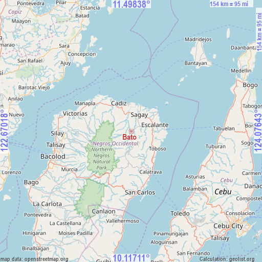
Bato GPS coordinates[2]
10° 48' 30.744" North, 123° 22' 23.88" East
| Map corner | latitude | longitude |
|---|---|---|
| Upper-left | 11.49838°, | 122.67018° |
| Center: | 10.80854°, | 123.3733° |
| Lower-right: | 10.11711°, | 124.07643° |
| Map W x H: | 153.6×153.6 km | = 95.4×95.4mi |
| max Lat: | 20.78733° ⇑59.4% North |
| Bato: | 10.80854° |
| min Lat: | ⇓40.6% South 4.65442° |
| min Long | Bato | max Long |
| 117.04868° | 123.3733° | 126.58417° |
| W 59.8%⇐ | ⇒40.2% E |
Elevation
Elevation of Bato is 90 m = 295 ft, and this is 2.1 m = 7 ft above average elevation for this country.
| Max E: |
2262 m = 7421 ft | 20.3% |
| Bato | 90 m 295 ft | |
| Avg. | 87.9 m = 288 ft | |
Min E: |
-2 m = -7 ft | 79.7% |
See also: Philippines elevation on elevation.city.
Geographical zone
Bato is located in North Torrid zone (between Equator and Tropic of Cancer). Distance of Equator is 1201.8 km =746.8 mi to South.| Distance of | km | miles | from Bato |
|---|---|---|---|
| North Pole | 8805.3 | 5471.4 | to North |
| Arctic Circle | 6199.4 | 3852.1 | to North |
| Tropic Cancer | 1404.1 | 872.5 | to North |
| Equator | 1201.8 | 746.8 | to South |


Nearby cities:
15 places around Bato: (largest is in red/bold)
• Bolanon
16.3 km =10.1 mi,  42°
42°
• Bugang
7.7 km =4.8 mi,  163°
163°
• Cervantes
17.6 km =10.9 mi,  66°
66°
• Escalante
14.2 km =8.8 mi,  75°
75°
• Lopez Jaena
6.2 km =3.9 mi,  45°
45°
• Mabini
12.2 km =7.6 mi,  96°
96°
• Maquiling
3.8 km =2.4 mi,  143°
143°
• Minapasoc
12.5 km =7.8 mi,  192°
192°
• Ogtongon
16.5 km =10.3 mi, 103°
• Paraiso
8.6 km =5.3 mi,  352°
352°
• Plaridel
16.1 km =10 mi, 52°
• Rizal
9.4 km =5.8 mi,  31°
31°
• Sagay
16.1 km =10 mi,  20°
20°
• Tamlang
9 km =5.6 mi, 77°
• Tiglauigan
16.1 km =10 mi, 353°
Sources, notices
• [Note1] Compared only with cities in Philippines existing in our database
• [Src1] Map data: © OpenStreetMap contributors (CC-BY-SA)
• [Src2] Other city data from geonames.org with taken over terms of usage.
• [Src3] Geographical zone / Annual Mean Temperature by Robert A. Rohde @ Wikipedia
