Taloy geodata
Taloy (Cordillera) is a populated place; located in Philippines in Asia/Manila (GMT+8) time zone. With population of 3,485 people, there are 2065 cities with bigger population in this country. Compared to other cities in Philippines, 90.1% of cities are located further ↓South; 90.8% of cities are located further →East and 92.8% of cities have lower elevation than Taloy. Note1


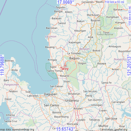
Taloy GPS coordinates[2]
16° 19' 59.988" North, 120° 30' 0" East
| Map corner | latitude | longitude |
|---|---|---|
| Upper-left | 17.0069°, | 119.79688° |
| Center: | 16.33333°, | 120.5° |
| Lower-right: | 15.65743°, | 121.20313° |
| Map W x H: | 150×150 km | = 93.2×93.2mi |
| max Lat: | 20.78733° ⇑9.9% North |
| Taloy: | 16.33333° |
| min Lat: | ⇓90.1% South 4.65442° |
| min Long | Taloy | max Long |
| 117.04868° | 120.5° | 126.58417° |
| W 9.2%⇐ | ⇒90.8% E |
Elevation
Elevation of Taloy is 321 m = 1053 ft, and this is 233.1 m = 765 ft above average elevation for this country.
| Max E: |
2262 m = 7421 ft | 7.2% |
| Taloy | 321 m 1053 ft | |
| Avg. | 87.9 m = 288 ft | |
Min E: |
-2 m = -7 ft | 92.8% |
See also: Philippines elevation on elevation.city.
Geographical zone
Taloy is located in North Torrid zone (between Equator and Tropic of Cancer). Distance of this Northern Tropic circle is 789.8 km =490.8 mi to North.| Distance of | km | miles | from Taloy |
|---|---|---|---|
| North Pole | 8191 | 5089.6 | to North |
| Arctic Circle | 5585.1 | 3470.4 | to North |
| Tropic Cancer | 789.8 | 490.8 | to North |
| Equator | 1816.1 | 1128.5 | to South |


Nearby cities:
15 places around Taloy: (largest is in red/bold)
• Bail
11.8 km =7.3 mi,  243°
243°
• Bayabas
13.1 km =8.1 mi,  7°
7°
• Caronoan West
9.7 km =6 mi,  216°
216°
• Halog West
9.8 km =6.1 mi,  292°
292°
• Inabaan Sur
8.2 km =5.1 mi,  196°
196°
• Leones East
12 km =7.5 mi, 286°
• Lloren
7.2 km =4.5 mi,  269°
269°
• Macalva Norte
12.2 km =7.6 mi,  277°
277°
• Nangalisan
11.5 km =7.1 mi,  348°
348°
• Pugo
3.7 km =2.3 mi,  250°
250°
• Rosario
11.5 km =7.1 mi,  187°
187°
• Subusub
11.8 km =7.3 mi,  182°
182°
• Tabaan
4.1 km =2.5 mi,  154°
154°
• Tuba
5.6 km =3.5 mi,  108°
108°
• Tubao
9.5 km =5.9 mi, 280°
Sources, notices
• [Note1] Compared only with cities in Philippines existing in our database
• [Src1] Map data: © OpenStreetMap contributors (CC-BY-SA)
• [Src2] Other city data from geonames.org with taken over terms of usage.
• [Src3] Geographical zone / Annual Mean Temperature by Robert A. Rohde @ Wikipedia
