Inabaan Sur geodata
Inabaan Sur (Ilocos) is a populated place; located in Philippines in Asia/Manila (GMT+8) time zone. With population of 2,831 people, there are 2739 cities with bigger population in this country. Compared to other cities in Philippines, 89.6% of cities are located further ↓South; 91.4% of cities are located further →East and 88% of cities have lower elevation than Inabaan Sur. Note1


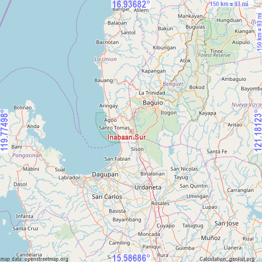
Inabaan Sur GPS coordinates[2]
16° 15' 46.8" North, 120° 28' 41.16" East
| Map corner | latitude | longitude |
|---|---|---|
| Upper-left | 16.93682°, | 119.77498° |
| Center: | 16.263°, | 120.4781° |
| Lower-right: | 15.58686°, | 121.18123° |
| Map W x H: | 150.1×150.1 km | = 93.3×93.3mi |
| max Lat: | 20.78733° ⇑10.4% North |
| Inabaan Sur: | 16.263° |
| min Lat: | ⇓89.6% South 4.65442° |
| min Long | Inabaan Sur | max Long |
| 117.04868° | 120.4781° | 126.58417° |
| W 8.6%⇐ | ⇒91.4% E |
Elevation
Elevation of Inabaan Sur is 180 m = 591 ft, and this is 92.1 m = 302 ft above average elevation for this country.
| Max E: |
2262 m = 7421 ft | 12% |
| Inabaan Sur | 180 m 591 ft | |
| Avg. | 87.9 m = 288 ft | |
Min E: |
-2 m = -7 ft | 88% |
See also: Philippines elevation on elevation.city.
Geographical zone
Inabaan Sur is located in North Torrid zone (between Equator and Tropic of Cancer). Distance of this Northern Tropic circle is 797.6 km =495.6 mi to North.| Distance of | km | miles | from Inabaan Sur |
|---|---|---|---|
| North Pole | 8198.8 | 5094.5 | to North |
| Arctic Circle | 5592.9 | 3475.3 | to North |
| Tropic Cancer | 797.6 | 495.6 | to North |
| Equator | 1808.3 | 1123.6 | to South |


Nearby cities:
15 places around Inabaan Sur: (largest is in red/bold)
• Bail
8.7 km =5.4 mi,  287°
287°
• Caronoan West
3.4 km =2.1 mi,  270°
270°
• Damortis
8.1 km =5 mi,  252°
252°
• Lloren
9.2 km =5.7 mi,  328°
328°
• Namboongan
11.8 km =7.3 mi, 292°
• Pugo
6.7 km =4.2 mi,  349°
349°
• Rosario
3.7 km =2.3 mi,  166°
166°
• Sagunto
8 km =5 mi,  150°
150°
• Santo Tomas
10.7 km =6.6 mi,  280°
280°
• Sison
10.7 km =6.6 mi,  158°
158°
• Subusub
4.4 km =2.7 mi, 155°
• Tabaan
5.8 km =3.6 mi,  45°
45°
• Taloy
8.2 km =5.1 mi,  16°
16°
• Tuba
9.7 km =6 mi, 51°
• Tubao
11.8 km =7.3 mi,  323°
323°
Sources, notices
• [Note1] Compared only with cities in Philippines existing in our database
• [Src1] Map data: © OpenStreetMap contributors (CC-BY-SA)
• [Src2] Other city data from geonames.org with taken over terms of usage.
• [Src3] Geographical zone / Annual Mean Temperature by Robert A. Rohde @ Wikipedia
