Nangalisan geodata
Nangalisan (Cordillera) is a populated place; located in Philippines in Asia/Manila (GMT+8) time zone. With population of 2,297 people, there are 3689 cities with bigger population in this country. Compared to other cities in Philippines, 90.7% of cities are located further ↓South; 91.4% of cities are located further →East and 88.1% of cities have lower elevation than Nangalisan. Note1


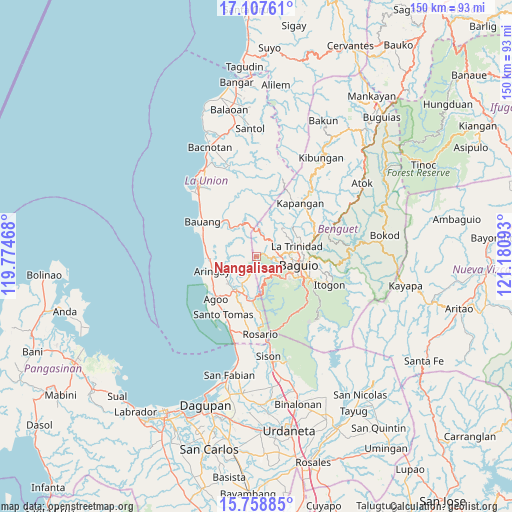
Nangalisan GPS coordinates[2]
16° 26' 3.84" North, 120° 28' 40.08" East
| Map corner | latitude | longitude |
|---|---|---|
| Upper-left | 17.10761°, | 119.77468° |
| Center: | 16.4344°, | 120.4778° |
| Lower-right: | 15.75885°, | 121.18093° |
| Map W x H: | 150×150 km | = 93.2×93.2mi |
| max Lat: | 20.78733° ⇑9.3% North |
| Nangalisan: | 16.4344° |
| min Lat: | ⇓90.7% South 4.65442° |
| min Long | Nangalisan | max Long |
| 117.04868° | 120.4778° | 126.58417° |
| W 8.6%⇐ | ⇒91.4% E |
Elevation
Elevation of Nangalisan is 183 m = 600 ft, and this is 95.1 m = 312 ft above average elevation for this country.
| Max E: |
2262 m = 7421 ft | 11.9% |
| Nangalisan | 183 m 600 ft | |
| Avg. | 87.9 m = 288 ft | |
Min E: |
-2 m = -7 ft | 88.1% |
See also: Philippines elevation on elevation.city.
Geographical zone
Nangalisan is located in North Torrid zone (between Equator and Tropic of Cancer). Distance of this Northern Tropic circle is 778.6 km =483.8 mi to North.| Distance of | km | miles | from Nangalisan |
|---|---|---|---|
| North Pole | 8179.7 | 5082.6 | to North |
| Arctic Circle | 5573.8 | 3463.4 | to North |
| Tropic Cancer | 778.6 | 483.8 | to North |
| Equator | 1827.3 | 1135.4 | to South |


Nearby cities:
15 places around Nangalisan: (largest is in red/bold)
• Aringay
13.9 km =8.6 mi,  251°
251°
• Baguio
12.5 km =7.8 mi,  99°
99°
• Bayabas
4.5 km =2.8 mi,  67°
67°
• Burgos
9.5 km =5.9 mi,  350°
350°
• Caba
14.2 km =8.8 mi,  268°
268°
• Halog West
10.1 km =6.3 mi,  221°
221°
• La Trinidad
11.9 km =7.4 mi,  78°
78°
• Leones East
12.1 km =7.5 mi,  229°
229°
• Lloren
12.2 km =7.6 mi,  203°
203°
• Macalva Norte
13.6 km =8.5 mi, 225°
• Naguilian
14 km =8.7 mi,  321°
321°
• Pugo
12.5 km =7.8 mi,  185°
185°
• Sablan
6.8 km =4.2 mi,  16°
16°
• Taloy
11.5 km =7.1 mi,  168°
168°
• Tubao
11.9 km =7.4 mi, 216°
Sources, notices
• [Note1] Compared only with cities in Philippines existing in our database
• [Src1] Map data: © OpenStreetMap contributors (CC-BY-SA)
• [Src2] Other city data from geonames.org with taken over terms of usage.
• [Src3] Geographical zone / Annual Mean Temperature by Robert A. Rohde @ Wikipedia
