Halog West geodata
Halog West (Ilocos) is a populated place; located in Philippines in Asia/Manila (GMT+8) time zone. With population of 2,496 people, there are 3298 cities with bigger population in this country. Compared to other cities in Philippines, 90.4% of cities are located further ↓South; 93.3% of cities are located further →East and 50.3% of cities have higher elevation than Halog West. Note1


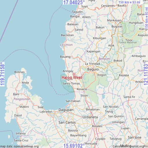
Halog West GPS coordinates[2]
16° 22' 0.48" North, 120° 24' 52.92" East
| Map corner | latitude | longitude |
|---|---|---|
| Upper-left | 17.04025°, | 119.71158° |
| Center: | 16.3668°, | 120.4147° |
| Lower-right: | 15.69102°, | 121.11783° |
| Map W x H: | 150×150 km | = 93.2×93.2mi |
| max Lat: | 20.78733° ⇑9.6% North |
| Halog West: | 16.3668° |
| min Lat: | ⇓90.4% South 4.65442° |
| min Long | Halog West | max Long |
| 117.04868° | 120.4147° | 126.58417° |
| W 6.7%⇐ | ⇒93.3% E |
Elevation
Elevation of Halog West is 23 m = 75 ft, and this is 64.9 m = 213 ft below average elevation for this country.
| Max E: |
2262 m = 7421 ft | 50.3% |
| Avg. | 87.9 m = 288 ft | |
| Halog West | 23 m = 75 ft | |
Min E: |
-2 m = -7 ft | 49.7% |
See also: Philippines elevation on elevation.city.
Geographical zone
Halog West is located in North Torrid zone (between Equator and Tropic of Cancer). Distance of this Northern Tropic circle is 786.1 km =488.5 mi to North.| Distance of | km | miles | from Halog West |
|---|---|---|---|
| North Pole | 8187.2 | 5087.3 | to North |
| Arctic Circle | 5581.4 | 3468.1 | to North |
| Tropic Cancer | 786.1 | 488.5 | to North |
| Equator | 1819.8 | 1130.8 | to South |


Nearby cities:
15 places around Halog West: (largest is in red/bold)
• Agoo
7.1 km =4.4 mi,  226°
226°
• Aringay
7.1 km =4.4 mi,  295°
295°
• Bail
9 km =5.6 mi,  189°
189°
• Caba
10.4 km =6.5 mi,  313°
313°
• Caronoan West
12 km =7.5 mi,  163°
163°
• Leones East
2.5 km =1.6 mi,  260°
260°
• Lloren
4.2 km =2.6 mi,  152°
152°
• Macalva Norte
3.6 km =2.2 mi,  235°
235°
• Namboongan
8.2 km =5.1 mi,  210°
210°
• Nangalisan
10.1 km =6.3 mi,  41°
41°
• Pugo
7.5 km =4.7 mi,  131°
131°
• San Eugenio
6.2 km =3.9 mi, 262°
• Santo Tomas
10.4 km =6.5 mi,  201°
201°
• Taloy
9.8 km =6.1 mi,  112°
112°
• Tubao
2.1 km =1.3 mi, 187°
Sources, notices
• [Note1] Compared only with cities in Philippines existing in our database
• [Src1] Map data: © OpenStreetMap contributors (CC-BY-SA)
• [Src2] Other city data from geonames.org with taken over terms of usage.
• [Src3] Geographical zone / Annual Mean Temperature by Robert A. Rohde @ Wikipedia
