Talisay geodata
Talisay (Western Visayas) is a populated place; located in Philippines in Asia/Manila (GMT+8) time zone. With population of 65,265 people, there are 146 cities with bigger population in this country. Compared to other cities in Philippines, 60.4% of cities are located further ↑North; 52.7% of cities are located further ←West and 80.7% of cities have higher elevation than Talisay. Note1
Administrative division(s):
- Level 1: Western Visayas
- Level 2: Province of Negros Occidental
- Level 3: City of Talisay


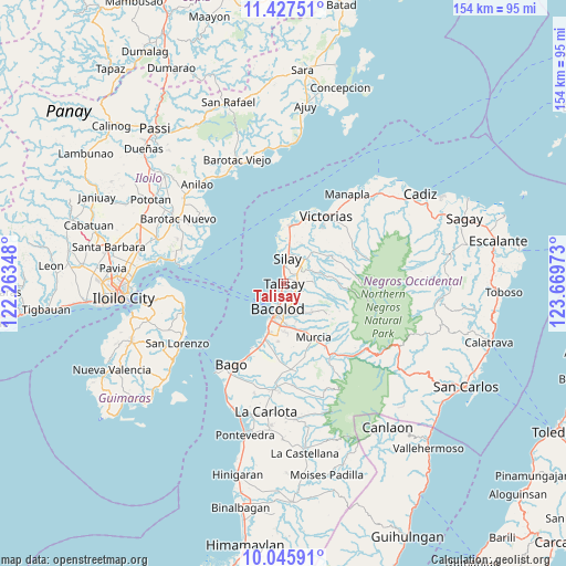
Talisay GPS coordinates[2]
10° 44' 15" North, 122° 57' 59.76" East
| Map corner | latitude | longitude |
|---|---|---|
| Upper-left | 11.42751°, | 122.26348° |
| Center: | 10.7375°, | 122.9666° |
| Lower-right: | 10.04591°, | 123.66973° |
| Map W x H: | 153.6×153.6 km | = 95.4×95.4mi |
| max Lat: | 20.78733° ⇑60.4% North |
| Talisay: | 10.7375° |
| min Lat: | ⇓39.6% South 4.65442° |
| min Long | Talisay | max Long |
| 117.04868° | 122.9666° | 126.58417° |
| W 52.7%⇐ | ⇒47.3% E |
Elevation
Elevation of Talisay is 9 m = 30 ft, and this is 78.9 m = 259 ft below average elevation for this country.
| Max E: |
2262 m = 7421 ft | 80.7% |
| Avg. | 87.9 m = 288 ft | |
| Talisay | 9 m = 30 ft | |
Min E: |
-2 m = -7 ft | 19.3% |
See also: Talisay elevation on elevation.city.
Geographical zone
Talisay is located in North Torrid zone (between Equator and Tropic of Cancer). Distance of Equator is 1193.9 km =741.9 mi to South.| Distance of | km | miles | from Talisay |
|---|---|---|---|
| North Pole | 8813.2 | 5476.3 | to North |
| Arctic Circle | 6207.3 | 3857 | to North |
| Tropic Cancer | 1412 | 877.4 | to North |
| Equator | 1193.9 | 741.9 | to South |


Nearby cities:
15 places around Talisay: (largest is in red/bold)
• Alacaygan
15.2 km =9.4 mi,  41°
41°
• Alegria
16.5 km =10.3 mi,  129°
129°
• Bacolod City
8.1 km =5 mi,  192°
192°
• Binonga
4.2 km =2.6 mi,  23°
23°
• Capitan Ramon
16.4 km =10.2 mi,  81°
81°
• Concepcion
11.5 km =7.1 mi,  116°
116°
• Dos Hermanas
7.8 km =4.8 mi,  86°
86°
• Eustaquio Lopez
12.2 km =7.6 mi, 41°
• Imbang
8.9 km =5.5 mi, 42°
• Mansilingan
11.9 km =7.4 mi,  173°
173°
• Nangka
15.2 km =9.4 mi,  29°
29°
• San Fernando
11.7 km =7.3 mi,  105°
105°
• Saravia
15.6 km =9.7 mi,  0°
0°
• Sumag
16 km =9.9 mi,  198°
198°
• Tanza
11.9 km =7.4 mi, 24°
Sources, notices
• [Note1] Compared only with cities in Philippines existing in our database
• [Src1] Map data: © OpenStreetMap contributors (CC-BY-SA)
• [Src2] Other city data from geonames.org with taken over terms of usage.
• [Src3] Geographical zone / Annual Mean Temperature by Robert A. Rohde @ Wikipedia
