San Fernando geodata
San Fernando (Western Visayas) is a populated place; located in Philippines in Asia/Manila (GMT+8) time zone. With population of 3,165 people, there are 2335 cities with bigger population in this country. Compared to other cities in Philippines, 60.7% of cities are located further ↑North; 54.6% of cities are located further ←West and 86.7% of cities have lower elevation than San Fernando. Note1
Administrative division(s):
- Level 1: Western Visayas
- Level 2: Province of Negros Occidental
- Level 3: City of Talisay


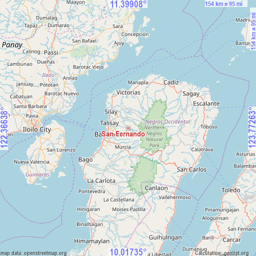
San Fernando GPS coordinates[2]
10° 42' 32.4" North, 123° 4' 10.2" East
| Map corner | latitude | longitude |
|---|---|---|
| Upper-left | 11.39908°, | 122.36638° |
| Center: | 10.709°, | 123.0695° |
| Lower-right: | 10.01735°, | 123.77263° |
| Map W x H: | 153.6×153.6 km | = 95.4×95.4mi |
| max Lat: | 20.78733° ⇑60.7% North |
| San Fernando: | 10.709° |
| min Lat: | ⇓39.3% South 4.65442° |
| min Long | San Fernando | max Long |
| 117.04868° | 123.0695° | 126.58417° |
| W 54.6%⇐ | ⇒45.4% E |
Elevation
Elevation of San Fernando is 160 m = 525 ft, and this is 72.1 m = 237 ft above average elevation for this country.
| Max E: |
2262 m = 7421 ft | 13.3% |
| San Fernando | 160 m 525 ft | |
| Avg. | 87.9 m = 288 ft | |
Min E: |
-2 m = -7 ft | 86.7% |
See also: Philippines elevation on elevation.city.
Geographical zone
San Fernando is located in North Torrid zone (between Equator and Tropic of Cancer). Distance of Equator is 1190.7 km =739.9 mi to South.| Distance of | km | miles | from San Fernando |
|---|---|---|---|
| North Pole | 8816.3 | 5478.2 | to North |
| Arctic Circle | 6210.4 | 3859 | to North |
| Tropic Cancer | 1415.2 | 879.4 | to North |
| Equator | 1190.7 | 739.9 | to South |


Nearby cities:
15 places around San Fernando: (largest is in red/bold)
• Alacaygan
14.6 km =9.1 mi,  355°
355°
• Alegria
7.4 km =4.6 mi,  168°
168°
• Bacolod City
13.9 km =8.6 mi,  250°
250°
• Binonga
11.9 km =7.4 mi,  306°
306°
• Buenavista
11 km =6.8 mi,  162°
162°
• Capitan Ramon
7.5 km =4.7 mi,  40°
40°
• Concepcion
2.1 km =1.3 mi,  206°
206°
• Dos Hermanas
5.1 km =3.2 mi,  316°
316°
• Eustaquio Lopez
12.7 km =7.9 mi,  345°
345°
• Imbang
11.1 km =6.9 mi,  331°
331°
• Mansilingan
13.2 km =8.2 mi,  228°
228°
• Murcia
11.9 km =7.4 mi,  194°
194°
• Santa Cruz
8.5 km =5.3 mi, 170°
• Talisay
11.7 km =7.3 mi,  285°
285°
• Tanza
15.4 km =9.6 mi,  335°
335°
Sources, notices
• [Note1] Compared only with cities in Philippines existing in our database
• [Src1] Map data: © OpenStreetMap contributors (CC-BY-SA)
• [Src2] Other city data from geonames.org with taken over terms of usage.
• [Src3] Geographical zone / Annual Mean Temperature by Robert A. Rohde @ Wikipedia
