Alegria geodata
Alegria (Western Visayas) is a populated place; located in Philippines in Asia/Manila (GMT+8) time zone. With population of 2,780 people, there are 2819 cities with bigger population in this country. Compared to other cities in Philippines, 61.6% of cities are located further ↑North; 54.8% of cities are located further ←West and 91.9% of cities have lower elevation than Alegria. Note1
Administrative division(s):
- Level 1: Western Visayas
- Level 2: Province of Negros Occidental
- Level 3: Murcia


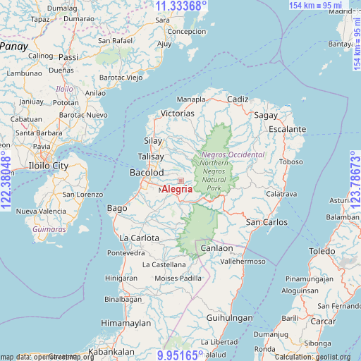
Alegria GPS coordinates[2]
10° 38' 36.42" North, 123° 5' 0.96" East
| Map corner | latitude | longitude |
|---|---|---|
| Upper-left | 11.33368°, | 122.38048° |
| Center: | 10.64345°, | 123.0836° |
| Lower-right: | 9.95165°, | 123.78673° |
| Map W x H: | 153.7×153.7 km | = 95.5×95.5mi |
| max Lat: | 20.78733° ⇑61.6% North |
| Alegria: | 10.64345° |
| min Lat: | ⇓38.4% South 4.65442° |
| min Long | Alegria | max Long |
| 117.04868° | 123.0836° | 126.58417° |
| W 54.8%⇐ | ⇒45.2% E |
Elevation
Elevation of Alegria is 283 m = 928 ft, and this is 195.1 m = 640 ft above average elevation for this country.
| Max E: |
2262 m = 7421 ft | 8.1% |
| Alegria | 283 m 928 ft | |
| Avg. | 87.9 m = 288 ft | |
Min E: |
-2 m = -7 ft | 91.9% |
See also: Philippines elevation on elevation.city.
Geographical zone
Alegria is located in North Torrid zone (between Equator and Tropic of Cancer). Distance of Equator is 1183.4 km =735.3 mi to South.| Distance of | km | miles | from Alegria |
|---|---|---|---|
| North Pole | 8823.6 | 5482.7 | to North |
| Arctic Circle | 6217.7 | 3863.5 | to North |
| Tropic Cancer | 1422.5 | 883.9 | to North |
| Equator | 1183.4 | 735.3 | to South |


Nearby cities:
15 places around Alegria: (largest is in red/bold)
• Bacolod City
14.8 km =9.2 mi,  280°
280°
• Buenavista
3.6 km =2.2 mi,  151°
151°
• Cansilayan
11.7 km =7.3 mi,  217°
217°
• Capitan Ramon
13.4 km =8.3 mi,  14°
14°
• Concepcion
5.9 km =3.7 mi,  335°
335°
• Dos Hermanas
12.1 km =7.5 mi, 335°
• Hacienda Santa Rosa
8.1 km =5 mi,  166°
166°
• Mansilingan
11.5 km =7.1 mi,  263°
263°
• Minuyan
14.6 km =9.1 mi, 170°
• Murcia
6.3 km =3.9 mi,  227°
227°
• New Pandanon
11.9 km =7.4 mi,  144°
144°
• San Fernando
7.4 km =4.6 mi,  348°
348°
• San Miguel
11.7 km =7.3 mi,  180°
180°
• Santa Cruz
1.1 km =0.7 mi,  188°
188°
• Talisay
16.5 km =10.3 mi,  309°
309°
Sources, notices
• [Note1] Compared only with cities in Philippines existing in our database
• [Src1] Map data: © OpenStreetMap contributors (CC-BY-SA)
• [Src2] Other city data from geonames.org with taken over terms of usage.
• [Src3] Geographical zone / Annual Mean Temperature by Robert A. Rohde @ Wikipedia
