Pandakan geodata
Pandakan (Autonomous Region in Muslim Mindanao) is a populated place; located in Philippines in Asia/Manila (GMT+8) time zone. With population of 3,162 people, there are 2338 cities with bigger population in this country. Compared to other cities in Philippines, 98% of cities are located further ↑North; 72.2% of cities are located further →East and 83.6% of cities have lower elevation than Pandakan. Note1
Administrative division(s):
- Level 1: Autonomous Region in Muslim Mindanao
- Level 2: Province of Sulu
- Level 3: Panglima Estino (New Panamao)


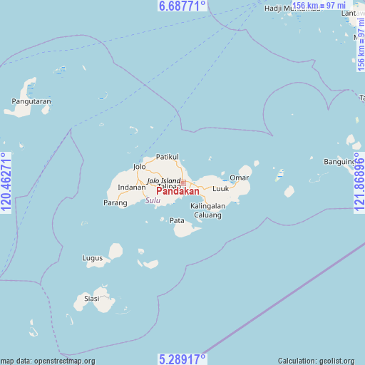
Pandakan GPS coordinates[2]
5° 59' 20.004" North, 121° 9' 56.988" East
| Map corner | latitude | longitude |
|---|---|---|
| Upper-left | 6.68771°, | 120.46271° |
| Center: | 5.98889°, | 121.16583° |
| Lower-right: | 5.28917°, | 121.86896° |
| Map W x H: | 155.5×155.5 km | = 96.6×96.6mi |
| max Lat: | 20.78733° ⇑98% North |
| Pandakan: | 5.98889° |
| min Lat: | ⇓2% South 4.65442° |
| min Long | Pandakan | max Long |
| 117.04868° | 121.16583° | 126.58417° |
| W 27.8%⇐ | ⇒72.2% E |
Elevation
Elevation of Pandakan is 122 m = 400 ft, and this is 34.1 m = 112 ft above average elevation for this country.
| Max E: |
2262 m = 7421 ft | 16.4% |
| Pandakan | 122 m 400 ft | |
| Avg. | 87.9 m = 288 ft | |
Min E: |
-2 m = -7 ft | 83.6% |
See also: Philippines elevation on elevation.city.
Geographical zone
Pandakan is located in North Torrid zone (between Equator and Tropic of Cancer). Distance of Equator is 665.9 km =413.8 mi to South.| Distance of | km | miles | from Pandakan |
|---|---|---|---|
| North Pole | 9341.2 | 5804.4 | to North |
| Arctic Circle | 6735.3 | 4185.1 | to North |
| Tropic Cancer | 1940 | 1205.5 | to North |
| Equator | 665.9 | 413.8 | to South |


Nearby cities:
15 places around Pandakan: (largest is in red/bold)
• Bangkal
14 km =8.7 mi,  308°
308°
• Binuang
12.2 km =7.6 mi,  253°
253°
• Kansipati
7.7 km =4.8 mi,  79°
79°
• Karungdong
15.8 km =9.8 mi,  137°
137°
• Kulay-Kulay
8.8 km =5.5 mi,  123°
123°
• Mahala
8.8 km =5.5 mi,  204°
204°
• Marsada
9.1 km =5.7 mi,  225°
225°
• Mauboh
8 km =5 mi,  270°
270°
• New Panamao
5.7 km =3.5 mi, 138°
• Pananaw
5.5 km =3.4 mi,  99°
99°
• Pang
14.3 km =8.9 mi,  108°
108°
• Patikul
13 km =8.1 mi,  329°
329°
• Punay
4.7 km =2.9 mi,  130°
130°
• Talipao
5.7 km =3.5 mi,  255°
255°
• Talipaw
11.8 km =7.3 mi,  221°
221°
Sources, notices
• [Note1] Compared only with cities in Philippines existing in our database
• [Src1] Map data: © OpenStreetMap contributors (CC-BY-SA)
• [Src2] Other city data from geonames.org with taken over terms of usage.
• [Src3] Geographical zone / Annual Mean Temperature by Robert A. Rohde @ Wikipedia
