Punay geodata
Punay (Autonomous Region in Muslim Mindanao) is a populated place; located in Philippines in Asia/Manila (GMT+8) time zone. With population of 6,099 people, there are 1029 cities with bigger population in this country. Compared to other cities in Philippines, 98.2% of cities are located further ↑North; 71.7% of cities are located further →East and 55.6% of cities have lower elevation than Punay. Note1
Administrative division(s):
- Level 1: Autonomous Region in Muslim Mindanao
- Level 2: Province of Sulu
- Level 3: Panglima Estino (New Panamao)


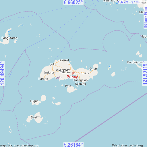
Punay GPS coordinates[2]
5° 57' 41.004" North, 121° 11' 53.016" East
| Map corner | latitude | longitude |
|---|---|---|
| Upper-left | 6.66025°, | 120.49494° |
| Center: | 5.96139°, | 121.19806° |
| Lower-right: | 5.26164°, | 121.90119° |
| Map W x H: | 155.5×155.5 km | = 96.6×96.6mi |
| max Lat: | 20.78733° ⇑98.2% North |
| Punay: | 5.96139° |
| min Lat: | ⇓1.8% South 4.65442° |
| min Long | Punay | max Long |
| 117.04868° | 121.19806° | 126.58417° |
| W 28.3%⇐ | ⇒71.7% E |
Elevation
Elevation of Punay is 28 m = 92 ft, and this is 59.9 m = 197 ft below average elevation for this country.
| Max E: |
2262 m = 7421 ft | 44.4% |
| Avg. | 87.9 m = 288 ft | |
| Punay | 28 m = 92 ft | |
Min E: |
-2 m = -7 ft | 55.6% |
See also: Philippines elevation on elevation.city.
Geographical zone
Punay is located in North Torrid zone (between Equator and Tropic of Cancer). Distance of Equator is 662.8 km =411.8 mi to South.| Distance of | km | miles | from Punay |
|---|---|---|---|
| North Pole | 9344.2 | 5806.2 | to North |
| Arctic Circle | 6738.3 | 4187 | to North |
| Tropic Cancer | 1943.1 | 1207.4 | to North |
| Equator | 662.8 | 411.8 | to South |


Nearby cities:
15 places around Punay: (largest is in red/bold)
• Kambing
12.2 km =7.6 mi,  97°
97°
• Kansipati
6 km =3.7 mi,  42°
42°
• Karungdong
11.2 km =7 mi,  140°
140°
• Kulay-Kulay
4.2 km =2.6 mi,  115°
115°
• Lu-uk
12.6 km =7.8 mi,  86°
86°
• Mahala
8.7 km =5.4 mi,  235°
235°
• Marsada
10.6 km =6.6 mi,  251°
251°
• Mauboh
12 km =7.5 mi,  285°
285°
• New Panamao
1.3 km =0.8 mi,  170°
170°
• Pananaw
2.9 km =1.8 mi, 40°
• Pandakan
4.7 km =2.9 mi,  310°
310°
• Pang
10.1 km =6.3 mi, 98°
• Talipao
9.2 km =5.7 mi,  280°
280°
• Talipaw
12.8 km =8 mi, 243°
• Tunggol
13.9 km =8.6 mi,  200°
200°
Sources, notices
• [Note1] Compared only with cities in Philippines existing in our database
• [Src1] Map data: © OpenStreetMap contributors (CC-BY-SA)
• [Src2] Other city data from geonames.org with taken over terms of usage.
• [Src3] Geographical zone / Annual Mean Temperature by Robert A. Rohde @ Wikipedia
