Tabiauan geodata
Tabiauan (Autonomous Region in Muslim Mindanao) is a populated place; located in Philippines in Asia/Manila (GMT+8) time zone. With population of 2,312 people, there are 3648 cities with bigger population in this country. Compared to other cities in Philippines, 97.7% of cities are located further ↑North; 61.6% of cities are located further →East and 98.1% of cities have higher elevation than Tabiauan. Note1
Administrative division(s):
- Level 1: Autonomous Region in Muslim Mindanao
- Level 2: Province of Sulu
- Level 3: Tongkil


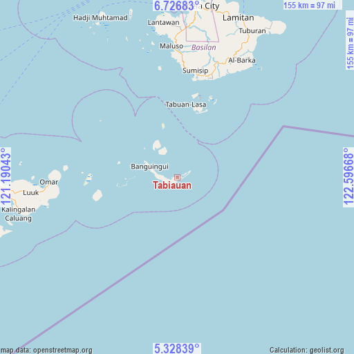
Tabiauan GPS coordinates[2]
6° 1' 41.016" North, 121° 53' 36.78" East
| Map corner | latitude | longitude |
|---|---|---|
| Upper-left | 6.72683°, | 121.19043° |
| Center: | 6.02806°, | 121.89355° |
| Lower-right: | 5.32839°, | 122.59668° |
| Map W x H: | 155.5×155.5 km | = 96.6×96.6mi |
| max Lat: | 20.78733° ⇑97.7% North |
| Tabiauan: | 6.02806° |
| min Lat: | ⇓2.3% South 4.65442° |
| min Long | Tabiauan | max Long |
| 117.04868° | 121.89355° | 126.58417° |
| W 38.4%⇐ | ⇒61.6% E |
Elevation
Elevation of Tabiauan is 3 m = 10 ft, and this is 84.9 m = 279 ft below average elevation for this country.
| Max E: |
2262 m = 7421 ft | 98.1% |
| Avg. | 87.9 m = 288 ft | |
| Tabiauan | 3 m = 10 ft | |
Min E: |
-2 m = -7 ft | 1.9% |
See also: Philippines elevation on elevation.city.
Geographical zone
Tabiauan is located in North Torrid zone (between Equator and Tropic of Cancer). Distance of Equator is 670.3 km =416.5 mi to South.| Distance of | km | miles | from Tabiauan |
|---|---|---|---|
| North Pole | 9336.8 | 5801.6 | to North |
| Arctic Circle | 6730.9 | 4182.4 | to North |
| Tropic Cancer | 1935.7 | 1202.8 | to North |
| Equator | 670.3 | 416.5 | to South |


Nearby cities:
15 places around Tabiauan: (largest is in red/bold)
• Andalan
56.2 km =34.9 mi,  262°
262°
• Guiong
45.8 km =28.5 mi,  18°
18°
• Kalang
59.9 km =37.2 mi, 258°
• Kambing
65.4 km =40.6 mi, 262°
• Kanlagay
68.7 km =42.7 mi, 255°
• Kansipati
72.9 km =45.3 mi,  267°
267°
• Karungdong
71.5 km =44.4 mi, 257°
• Lu-uk
64.6 km =40.1 mi, 264°
• Maluso
57.3 km =35.6 mi,  357°
357°
• Pang
67.5 km =41.9 mi, 262°
• Pitogo
66.1 km =41.1 mi, 256°
• Sumisip
44.4 km =27.6 mi,  11°
11°
• Tablas
73.7 km =45.8 mi, 24°
• Tairan Camp
68.3 km =42.4 mi,  354°
354°
• Tipo-Tipo
69.2 km =43 mi,  27°
27°
Sources, notices
• [Note1] Compared only with cities in Philippines existing in our database
• [Src1] Map data: © OpenStreetMap contributors (CC-BY-SA)
• [Src2] Other city data from geonames.org with taken over terms of usage.
• [Src3] Geographical zone / Annual Mean Temperature by Robert A. Rohde @ Wikipedia
