Kambing geodata
Kambing (Autonomous Region in Muslim Mindanao) is a populated place; located in Philippines in Asia/Manila (GMT+8) time zone. With population of 2,373 people, there are 3511 cities with bigger population in this country. Compared to other cities in Philippines, 98.3% of cities are located further ↑North; 70% of cities are located further →East and 81.7% of cities have lower elevation than Kambing. Note1
Administrative division(s):
- Level 1: Autonomous Region in Muslim Mindanao
- Level 2: Province of Sulu
- Level 3: Luuk


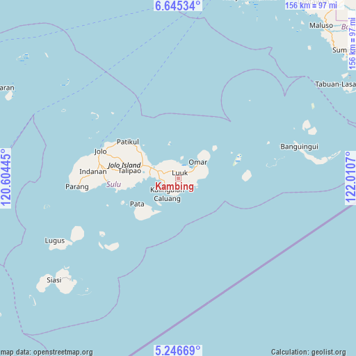
Kambing GPS coordinates[2]
5° 56' 47.256" North, 121° 18' 27.252" East
| Map corner | latitude | longitude |
|---|---|---|
| Upper-left | 6.64534°, | 120.60445° |
| Center: | 5.94646°, | 121.30757° |
| Lower-right: | 5.24669°, | 122.0107° |
| Map W x H: | 155.5×155.5 km | = 96.6×96.6mi |
| max Lat: | 20.78733° ⇑98.3% North |
| Kambing: | 5.94646° |
| min Lat: | ⇓1.7% South 4.65442° |
| min Long | Kambing | max Long |
| 117.04868° | 121.30757° | 126.58417° |
| W 30%⇐ | ⇒70% E |
Elevation
Elevation of Kambing is 104 m = 341 ft, and this is 16.1 m = 53 ft above average elevation for this country.
| Max E: |
2262 m = 7421 ft | 18.3% |
| Kambing | 104 m 341 ft | |
| Avg. | 87.9 m = 288 ft | |
Min E: |
-2 m = -7 ft | 81.7% |
See also: Philippines elevation on elevation.city.
Geographical zone
Kambing is located in North Torrid zone (between Equator and Tropic of Cancer). Distance of Equator is 661.2 km =410.9 mi to South.| Distance of | km | miles | from Kambing |
|---|---|---|---|
| North Pole | 9345.9 | 5807.3 | to North |
| Arctic Circle | 6740 | 4188 | to North |
| Tropic Cancer | 1944.7 | 1208.4 | to North |
| Equator | 661.2 | 410.9 | to South |


Nearby cities:
15 places around Kambing: (largest is in red/bold)
• Andalan
9.3 km =5.8 mi,  81°
81°
• Kalang
6.8 km =4.2 mi,  115°
115°
• Kanlagay
8.1 km =5 mi,  192°
192°
• Kansipati
10.1 km =6.3 mi,  306°
306°
• Karungdong
8.5 km =5.3 mi,  215°
215°
• Kulay-Kulay
8.3 km =5.2 mi,  269°
269°
• Lu-uk
2.5 km =1.6 mi,  11°
11°
• Mahala
19.6 km =12.2 mi,  260°
260°
• New Panamao
11.9 km =7.4 mi, 271°
• Pananaw
11 km =6.8 mi,  290°
290°
• Pandakan
16.4 km =10.2 mi, 286°
• Pang
2.1 km =1.3 mi,  275°
275°
• Pitogo
6.5 km =4 mi,  175°
175°
• Punay
12.2 km =7.6 mi, 277°
• Tunggol
20.4 km =12.7 mi,  236°
236°
Sources, notices
• [Note1] Compared only with cities in Philippines existing in our database
• [Src1] Map data: © OpenStreetMap contributors (CC-BY-SA)
• [Src2] Other city data from geonames.org with taken over terms of usage.
• [Src3] Geographical zone / Annual Mean Temperature by Robert A. Rohde @ Wikipedia
