San Agustin geodata
San Agustin (Mimaropa) is a populated place; located in Philippines in Asia/Manila (GMT+8) time zone. With population of 3,097 people, there are 2420 cities with bigger population in this country. Compared to other cities in Philippines, 59.8% of cities are located further ↓South; 70.1% of cities are located further →East and 70.2% of cities have higher elevation than San Agustin. Note1


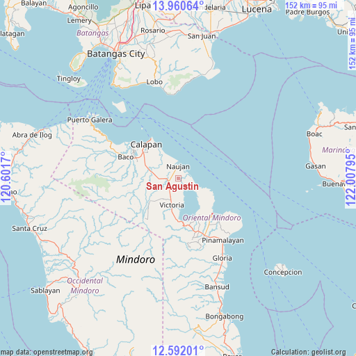
San Agustin GPS coordinates[2]
13° 16' 38.244" North, 121° 18' 17.352" East
| Map corner | latitude | longitude |
|---|---|---|
| Upper-left | 13.96064°, | 120.6017° |
| Center: | 13.27729°, | 121.30482° |
| Lower-right: | 12.59201°, | 122.00795° |
| Map W x H: | 152.2×152.2 km | = 94.6×94.6mi |
| max Lat: | 20.78733° ⇑40.2% North |
| San Agustin: | 13.27729° |
| min Lat: | ⇓59.8% South 4.65442° |
| min Long | San Agustin | max Long |
| 117.04868° | 121.30482° | 126.58417° |
| W 29.9%⇐ | ⇒70.1% E |
Elevation
Elevation of San Agustin is 12 m = 39 ft, and this is 75.9 m = 249 ft below average elevation for this country.
| Max E: |
2262 m = 7421 ft | 70.2% |
| Avg. | 87.9 m = 288 ft | |
| San Agustin | 12 m = 39 ft | |
Min E: |
-2 m = -7 ft | 29.8% |
See also: Philippines elevation on elevation.city.
Geographical zone
San Agustin is located in North Torrid zone (between Equator and Tropic of Cancer). Distance of this Northern Tropic circle is 1129.6 km =701.9 mi to North.| Distance of | km | miles | from San Agustin |
|---|---|---|---|
| North Pole | 8530.8 | 5300.8 | to North |
| Arctic Circle | 5924.9 | 3681.6 | to North |
| Tropic Cancer | 1129.6 | 701.9 | to North |
| Equator | 1476.3 | 917.3 | to South |


Nearby cities:
15 places around San Agustin: (largest is in red/bold)
• Apitong
11.4 km =7.1 mi,  248°
248°
• Bayanan
17.2 km =10.7 mi,  301°
301°
• Biga
16 km =9.9 mi,  283°
283°
• Calapan
20.1 km =12.5 mi,  317°
317°
• Canubing No 2
20.2 km =12.6 mi,  293°
293°
• Communal
18.4 km =11.4 mi,  262°
262°
• Estrella
5.8 km =3.6 mi,  6°
6°
• Manogpi
11.5 km =7.1 mi, 288°
• Nagiba
6.7 km =4.2 mi,  330°
330°
• Naujan
5.1 km =3.2 mi,  357°
357°
• Pinagsabangan
4.2 km =2.6 mi, 251°
• Saaban
17.7 km =11 mi,  157°
157°
• San Vincente
20.1 km =12.5 mi, 315°
• Sapol
15.9 km =9.9 mi,  307°
307°
• Victoria
11.5 km =7.1 mi,  194°
194°
Sources, notices
• [Note1] Compared only with cities in Philippines existing in our database
• [Src1] Map data: © OpenStreetMap contributors (CC-BY-SA)
• [Src2] Other city data from geonames.org with taken over terms of usage.
• [Src3] Geographical zone / Annual Mean Temperature by Robert A. Rohde @ Wikipedia
