Tubod geodata
Tubod (Caraga) is a seat of a third-order administrative division; located in Philippines in Asia/Manila (GMT+8) time zone. In our database, there are 4166 cities with bigger population. Compared to other cities in Philippines, 72.9% of cities are located further ↑North; 94.2% of cities are located further ←West and 70.8% of cities have lower elevation than Tubod. Note1


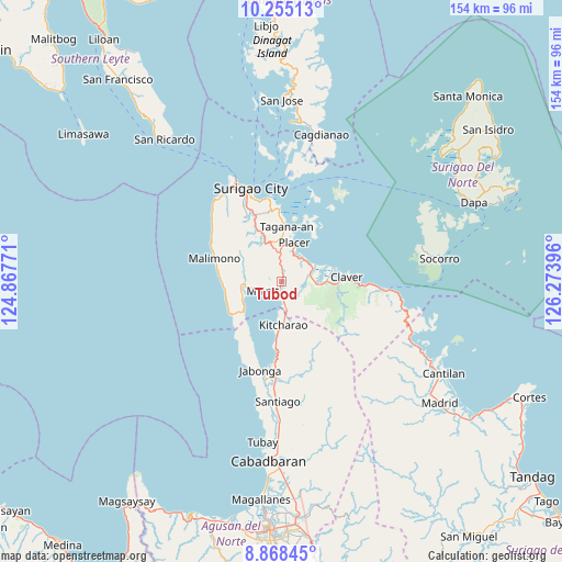
Tubod GPS coordinates[2]
9° 33' 45" North, 125° 34' 14.988" East
| Map corner | latitude | longitude |
|---|---|---|
| Upper-left | 10.25513°, | 124.86771° |
| Center: | 9.5625°, | 125.57083° |
| Lower-right: | 8.86845°, | 126.27396° |
| Map W x H: | 154.2×154.2 km | = 95.8×95.8mi |
| max Lat: | 20.78733° ⇑72.9% North |
| Tubod: | 9.5625° |
| min Lat: | ⇓27.1% South 4.65442° |
| min Long | Tubod | max Long |
| 117.04868° | 125.57083° | 126.58417° |
| W 94.2%⇐ | ⇒5.8% E |
Elevation
Elevation of Tubod is 54 m = 177 ft, and this is 33.9 m = 111 ft below average elevation for this country.
| Max E: |
2262 m = 7421 ft | 29.2% |
| Avg. | 87.9 m = 288 ft | |
| Tubod | 54 m = 177 ft | |
Min E: |
-2 m = -7 ft | 70.8% |
See also: Philippines elevation on elevation.city.
Geographical zone
Tubod is located in North Torrid zone (between Equator and Tropic of Cancer). Distance of Equator is 1063.3 km =660.7 mi to South.| Distance of | km | miles | from Tubod |
|---|---|---|---|
| North Pole | 8943.8 | 5557.4 | to North |
| Arctic Circle | 6337.9 | 3938.2 | to North |
| Tropic Cancer | 1542.7 | 958.6 | to North |
| Equator | 1063.3 | 660.7 | to South |


Nearby cities:
15 places around Tubod: (largest is in red/bold)
• Alegria
10.6 km =6.6 mi,  176°
176°
• Bacuag
9 km =5.6 mi,  55°
55°
• Cantapoy
16.8 km =10.4 mi,  241°
241°
• Capalayan
20 km =12.4 mi,  351°
351°
• Claver
17.8 km =11.1 mi,  86°
86°
• Gigaquit
14.3 km =8.9 mi,  75°
75°
• Kitcharao
12 km =7.5 mi, 178°
• Luna
21 km =13 mi,  337°
337°
• Mainit
6.1 km =3.8 mi, 239°
• Malimono
19.5 km =12.1 mi,  288°
288°
• Mati
22.3 km =13.9 mi,  329°
329°
• Placer
10.8 km =6.7 mi,  18°
18°
• San Francisco
10.1 km =6.3 mi,  247°
247°
• Sison
11.8 km =7.3 mi, 336°
• Tagana-an
15.1 km =9.4 mi,  6°
6°
Sources, notices
• [Note1] Compared only with cities in Philippines existing in our database
• [Src1] Map data: © OpenStreetMap contributors (CC-BY-SA)
• [Src2] Other city data from geonames.org with taken over terms of usage.
• [Src3] Geographical zone / Annual Mean Temperature by Robert A. Rohde @ Wikipedia
