Simala geodata
Simala (Central Visayas) is a populated place; located in Philippines in Asia/Manila (GMT+8) time zone. With population of 2,569 people, there are 3167 cities with bigger population in this country. Compared to other cities in Philippines, 68.6% of cities are located further ↑North; 64.2% of cities are located further ←West and 62.8% of cities have higher elevation than Simala. Note1


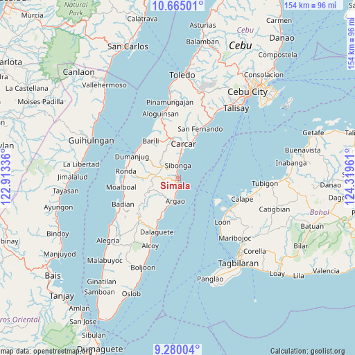
Simala GPS coordinates[2]
9° 58' 23.736" North, 123° 36' 59.328" East
| Map corner | latitude | longitude |
|---|---|---|
| Upper-left | 10.66501°, | 122.91336° |
| Center: | 9.97326°, | 123.61648° |
| Lower-right: | 9.28004°, | 124.31961° |
| Map W x H: | 154×154 km | = 95.7×95.7mi |
| max Lat: | 20.78733° ⇑68.6% North |
| Simala: | 9.97326° |
| min Lat: | ⇓31.4% South 4.65442° |
| min Long | Simala | max Long |
| 117.04868° | 123.61648° | 126.58417° |
| W 64.2%⇐ | ⇒35.8% E |
Elevation
Elevation of Simala is 15 m = 49 ft, and this is 72.9 m = 239 ft below average elevation for this country.
| Max E: |
2262 m = 7421 ft | 62.8% |
| Avg. | 87.9 m = 288 ft | |
| Simala | 15 m = 49 ft | |
Min E: |
-2 m = -7 ft | 37.2% |
See also: Philippines elevation on elevation.city.
Geographical zone
Simala is located in North Torrid zone (between Equator and Tropic of Cancer). Distance of Equator is 1108.9 km =689 mi to South.| Distance of | km | miles | from Simala |
|---|---|---|---|
| North Pole | 8898.1 | 5529 | to North |
| Arctic Circle | 6292.3 | 3909.9 | to North |
| Tropic Cancer | 1497 | 930.2 | to North |
| Equator | 1108.9 | 689 | to South |


Nearby cities:
15 places around Simala: (largest is in red/bold)
• Argao
10.7 km =6.6 mi,  192°
192°
• Binlod
6.2 km =3.9 mi, 189°
• Bogo
14.2 km =8.8 mi,  203°
203°
• Bulasa
4.6 km =2.9 mi,  177°
177°
• Calidñgan
14.2 km =8.8 mi,  7°
7°
• Cansuje
14.3 km =8.9 mi,  247°
247°
• Carcar
15 km =9.3 mi, 9°
• Guadalupe
16 km =9.9 mi,  356°
356°
• Jampang
7.5 km =4.7 mi, 193°
• Langtad
9.2 km =5.7 mi, 188°
• Ocaña
10.3 km =6.4 mi,  4°
4°
• Perrelos
17.2 km =10.7 mi,  21°
21°
• Sibonga
4.8 km =3 mi, 0°
• Tubod
5.5 km =3.4 mi,  297°
297°
• Tubod-dugoan
15.1 km =9.4 mi, 301°
Sources, notices
• [Note1] Compared only with cities in Philippines existing in our database
• [Src1] Map data: © OpenStreetMap contributors (CC-BY-SA)
• [Src2] Other city data from geonames.org with taken over terms of usage.
• [Src3] Geographical zone / Annual Mean Temperature by Robert A. Rohde @ Wikipedia
