Seres geodata
Seres (Zamboanga Peninsula) is a populated place; located in Philippines in Asia/Manila (GMT+8) time zone. With population of 2,128 people, there are 4031 cities with bigger population in this country. Compared to other cities in Philippines, 78.9% of cities are located further ↑North; 57.6% of cities are located further ←West and 74.3% of cities have lower elevation than Seres. Note1
Administrative division(s):
- Level 1: Zamboanga Peninsula
- Level 2: Province of Zamboanga del Norte
- Level 3: Katipunan


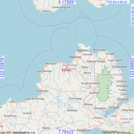
Seres GPS coordinates[2]
8° 28' 49.08" North, 123° 15' 46.44" East
| Map corner | latitude | longitude |
|---|---|---|
| Upper-left | 9.17509°, | 122.55978° |
| Center: | 8.4803°, | 123.2629° |
| Lower-right: | 7.78425°, | 123.96603° |
| Map W x H: | 154.6×154.7 km | = 96.1×96.1mi |
| max Lat: | 20.78733° ⇑78.9% North |
| Seres: | 8.4803° |
| min Lat: | ⇓21.1% South 4.65442° |
| min Long | Seres | max Long |
| 117.04868° | 123.2629° | 126.58417° |
| W 57.6%⇐ | ⇒42.4% E |
Elevation
Elevation of Seres is 66 m = 217 ft, and this is 21.9 m = 72 ft below average elevation for this country.
| Max E: |
2262 m = 7421 ft | 25.7% |
| Avg. | 87.9 m = 288 ft | |
| Seres | 66 m = 217 ft | |
Min E: |
-2 m = -7 ft | 74.3% |
See also: Philippines elevation on elevation.city.
Geographical zone
Seres is located in North Torrid zone (between Equator and Tropic of Cancer). Distance of Equator is 942.9 km =585.9 mi to South.| Distance of | km | miles | from Seres |
|---|---|---|---|
| North Pole | 9064.1 | 5632.2 | to North |
| Arctic Circle | 6458.3 | 4013 | to North |
| Tropic Cancer | 1663 | 1033.3 | to North |
| Equator | 942.9 | 585.9 | to South |


Nearby cities:
15 places around Seres: (largest is in red/bold)
• Barcelona
22.2 km =13.8 mi,  76°
76°
• Dapitan
26.3 km =16.3 mi,  41°
41°
• Dipolog
12.5 km =7.8 mi, 39°
• Ilaya
19.9 km =12.4 mi,  68°
68°
• Irasan
8.1 km =5 mi,  309°
309°
• Katipunan
4.3 km =2.7 mi,  30°
30°
• Langatian
5.6 km =3.5 mi,  323°
323°
• Linay
14.8 km =9.2 mi,  285°
285°
• Lingasan
15.2 km =9.4 mi, 83°
• Manukan
18.9 km =11.7 mi, 288°
• Olingan
9.1 km =5.7 mi,  45°
45°
• Polanco
12.3 km =7.6 mi,  61°
61°
• Ponot
26.7 km =16.6 mi,  263°
263°
• Siayan
29.8 km =18.5 mi,  217°
217°
• Sibutao
27.5 km =17.1 mi, 63°
Sources, notices
• [Note1] Compared only with cities in Philippines existing in our database
• [Src1] Map data: © OpenStreetMap contributors (CC-BY-SA)
• [Src2] Other city data from geonames.org with taken over terms of usage.
• [Src3] Geographical zone / Annual Mean Temperature by Robert A. Rohde @ Wikipedia
