Del Monte geodata
Del Monte (Zamboanga Peninsula) is a populated place; located in Philippines in Asia/Manila (GMT+8) time zone. With population of 2,213 people, there are 3861 cities with bigger population in this country. Compared to other cities in Philippines, 85% of cities are located further ↑North; 53.3% of cities are located further ←West and 89.5% of cities have lower elevation than Del Monte. Note1
Administrative division(s):
- Level 1: Zamboanga Peninsula
- Level 2: Province of Zamboanga Sibugay
- Level 3: Buug


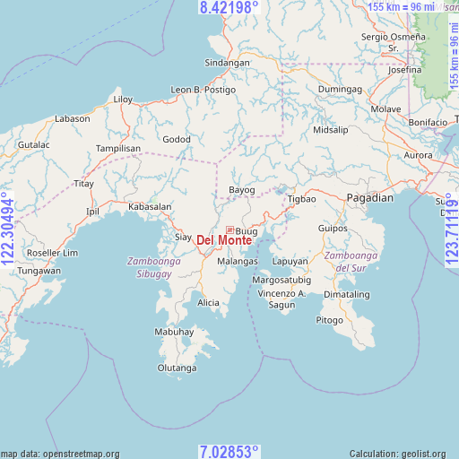
Del Monte GPS coordinates[2]
7° 43' 32.988" North, 123° 0' 29.016" East
| Map corner | latitude | longitude |
|---|---|---|
| Upper-left | 8.42198°, | 122.30494° |
| Center: | 7.72583°, | 123.00806° |
| Lower-right: | 7.02853°, | 123.71119° |
| Map W x H: | 154.9×154.9 km | = 96.3×96.3mi |
| max Lat: | 20.78733° ⇑85% North |
| Del Monte: | 7.72583° |
| min Lat: | ⇓15% South 4.65442° |
| min Long | Del Monte | max Long |
| 117.04868° | 123.00806° | 126.58417° |
| W 53.3%⇐ | ⇒46.7% E |
Elevation
Elevation of Del Monte is 219 m = 719 ft, and this is 131.1 m = 430 ft above average elevation for this country.
| Max E: |
2262 m = 7421 ft | 10.5% |
| Del Monte | 219 m 719 ft | |
| Avg. | 87.9 m = 288 ft | |
Min E: |
-2 m = -7 ft | 89.5% |
See also: Philippines elevation on elevation.city.
Geographical zone
Del Monte is located in North Torrid zone (between Equator and Tropic of Cancer). Distance of Equator is 859 km =533.8 mi to South.| Distance of | km | miles | from Del Monte |
|---|---|---|---|
| North Pole | 9148 | 5684.3 | to North |
| Arctic Circle | 6542.1 | 4065.1 | to North |
| Tropic Cancer | 1746.9 | 1085.5 | to North |
| Equator | 859 | 533.8 | to South |


Nearby cities:
15 places around Del Monte: (largest is in red/bold)
• Batu
19.9 km =12.4 mi,  278°
278°
• Bayog
16.9 km =10.5 mi,  22°
22°
• Buug
5.7 km =3.5 mi,  86°
86°
• Diplahan
1.4 km =0.9 mi,  137°
137°
• Dipolo
13.5 km =8.4 mi,  61°
61°
• Ganyangan
12.1 km =7.5 mi,  244°
244°
• Imelda
10.6 km =6.6 mi,  214°
214°
• Kumalarang
15.2 km =9.4 mi,  80°
80°
• La Dicha
5.6 km =3.5 mi,  186°
186°
• Lapuyan
22.7 km =14.1 mi,  115°
115°
• Malangas
10.9 km =6.8 mi,  166°
166°
• Monching
15.6 km =9.7 mi,  265°
265°
• Rancheria Payau
22 km =13.7 mi,  49°
49°
• Siay
16.3 km =10.1 mi,  258°
258°
• Tiguha
22.5 km =14 mi,  96°
96°
Sources, notices
• [Note1] Compared only with cities in Philippines existing in our database
• [Src1] Map data: © OpenStreetMap contributors (CC-BY-SA)
• [Src2] Other city data from geonames.org with taken over terms of usage.
• [Src3] Geographical zone / Annual Mean Temperature by Robert A. Rohde @ Wikipedia
