Kabasalan geodata
Kabasalan (Zamboanga Peninsula) is a seat of a third-order administrative division; located in Philippines in Asia/Manila (GMT+8) time zone. In our database, there are 4166 cities with bigger population. Compared to other cities in Philippines, 84.3% of cities are located further ↑North; 50.6% of cities are located further →East and 85.4% of cities have higher elevation than Kabasalan. Note1
Administrative division(s):
- Level 1: Zamboanga Peninsula
- Level 2: Province of Zamboanga Sibugay
- Level 3: Kabasalan


Kabasalan GPS coordinates[2]
7° 47' 49.992" North, 122° 45' 54" East
| Map corner | latitude | longitude |
|---|---|---|
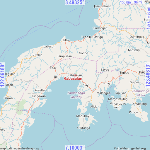
| Upper-left | 8.49325°, | 122.06188° |
| Center: | 7.79722°, | 122.765° |
| Lower-right: | 7.10003°, | 123.46813° |
| Map W x H: | 154.9×154.9 km | = 96.3×96.3mi |
| max Lat: | 20.78733° ⇑84.3% North |
| Kabasalan: | 7.79722° |
| min Lat: | ⇓15.7% South 4.65442° |
| min Long | Kabasalan | max Long |
| 117.04868° | 122.765° | 126.58417° |
| W 49.4%⇐ | ⇒50.6% E |
Elevation
Elevation of Kabasalan is 8 m = 26 ft, and this is 79.9 m = 262 ft below average elevation for this country.
| Max E: |
2262 m = 7421 ft | 85.4% |
| Avg. | 87.9 m = 288 ft | |
| Kabasalan | 8 m = 26 ft | |
Min E: |
-2 m = -7 ft | 14.6% |
See also: Philippines elevation on elevation.city.
Geographical zone
Kabasalan is located in North Torrid zone (between Equator and Tropic of Cancer). Distance of Equator is 867 km =538.7 mi to South.| Distance of | km | miles | from Kabasalan |
|---|---|---|---|
| North Pole | 9140.1 | 5679.4 | to North |
| Arctic Circle | 6534.2 | 4060.2 | to North |
| Tropic Cancer | 1738.9 | 1080.5 | to North |
| Equator | 867 | 538.7 | to South |


Nearby cities:
15 places around Kabasalan: (largest is in red/bold)
• Batu
8.6 km =5.3 mi,  124°
124°
• Dalangin
21.4 km =13.3 mi,  286°
286°
• Del Monte
27.9 km =17.3 mi,  106°
106°
• Diplahan
29.1 km =18.1 mi, 107°
• Ganyangan
20.6 km =12.8 mi,  129°
129°
• Imelda
26.6 km =16.5 mi, 128°
• Ipil
19.8 km =12.3 mi,  265°
265°
• Katipunan
24.9 km =15.5 mi,  163°
163°
• Monching
14.4 km =8.9 mi, 129°
• Naga
3.4 km =2.1 mi,  207°
207°
• Palomoc
24 km =14.9 mi,  303°
303°
• Payao
23.8 km =14.8 mi,  169°
169°
• Siay
15.6 km =9.7 mi,  136°
136°
• Tampilisan
26 km =16.2 mi,  339°
339°
• Titay
25.5 km =15.8 mi, 273°
Sources, notices
• [Note1] Compared only with cities in Philippines existing in our database
• [Src1] Map data: © OpenStreetMap contributors (CC-BY-SA)
• [Src2] Other city data from geonames.org with taken over terms of usage.
• [Src3] Geographical zone / Annual Mean Temperature by Robert A. Rohde @ Wikipedia
