Dapitan geodata
Dapitan (Zamboanga Peninsula) is a populated place; located in Philippines in Asia/Manila (GMT+8) time zone. With population of 50,514 people, there are 174 cities with bigger population in this country. Compared to other cities in Philippines, 77.3% of cities are located further ↑North; 60.8% of cities are located further ←West and 89.7% of cities have higher elevation than Dapitan. Note1
Administrative division(s):
- Level 1: Zamboanga Peninsula
- Level 2: Province of Zamboanga del Norte
- Level 3: Dapitan City


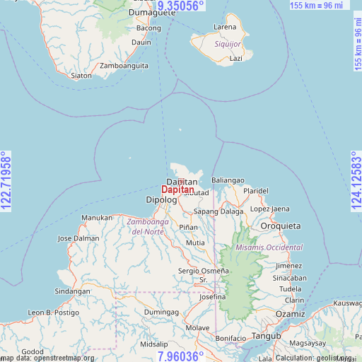
Dapitan GPS coordinates[2]
8° 39' 21.96" North, 123° 25' 21.72" East
| Map corner | latitude | longitude |
|---|---|---|
| Upper-left | 9.35056°, | 122.71958° |
| Center: | 8.6561°, | 123.4227° |
| Lower-right: | 7.96036°, | 124.12583° |
| Map W x H: | 154.6×154.6 km | = 96.1×96.1mi |
| max Lat: | 20.78733° ⇑77.3% North |
| Dapitan: | 8.6561° |
| min Lat: | ⇓22.7% South 4.65442° |
| min Long | Dapitan | max Long |
| 117.04868° | 123.4227° | 126.58417° |
| W 60.8%⇐ | ⇒39.2% E |
Elevation
Elevation of Dapitan is 7 m = 23 ft, and this is 80.9 m = 265 ft below average elevation for this country.
| Max E: |
2262 m = 7421 ft | 89.7% |
| Avg. | 87.9 m = 288 ft | |
| Dapitan | 7 m = 23 ft | |
Min E: |
-2 m = -7 ft | 10.3% |
See also: Dapitan elevation on elevation.city.
Geographical zone
Dapitan is located in North Torrid zone (between Equator and Tropic of Cancer). Distance of Equator is 962.5 km =598.1 mi to South.| Distance of | km | miles | from Dapitan |
|---|---|---|---|
| North Pole | 9044.6 | 5620.1 | to North |
| Arctic Circle | 6438.7 | 4000.8 | to North |
| Tropic Cancer | 1643.5 | 1021.2 | to North |
| Equator | 962.5 | 598.1 | to South |


Nearby cities:
15 places around Dapitan: (largest is in red/bold)
• Barcelona
14.8 km =9.2 mi,  164°
164°
• Bato
25.1 km =15.6 mi,  103°
103°
• Calamba
26.5 km =16.5 mi,  114°
114°
• Dipolog
13.8 km =8.6 mi,  224°
224°
• Ilaya
12.3 km =7.6 mi,  175°
175°
• Irasan
27.9 km =17.3 mi,  238°
238°
• Katipunan
22 km =13.7 mi, 224°
• Langatian
25.8 km =16 mi,  234°
234°
• Lingasan
17.9 km =11.1 mi,  188°
188°
• Olingan
17.2 km =10.7 mi, 220°
• Polanco
15.3 km =9.5 mi,  206°
206°
• Sapang Dalaga
20.1 km =12.5 mi,  130°
130°
• Seres
26.3 km =16.3 mi, 221°
• Sibutao
10 km =6.2 mi,  135°
135°
• Unidos
27.8 km =17.3 mi, 104°
Sources, notices
• [Note1] Compared only with cities in Philippines existing in our database
• [Src1] Map data: © OpenStreetMap contributors (CC-BY-SA)
• [Src2] Other city data from geonames.org with taken over terms of usage.
• [Src3] Geographical zone / Annual Mean Temperature by Robert A. Rohde @ Wikipedia
