Katipunan geodata
Katipunan (Zamboanga Peninsula) is a populated place; located in Philippines in Asia/Manila (GMT+8) time zone. With population of 4,172 people, there are 1634 cities with bigger population in this country. Compared to other cities in Philippines, 78.6% of cities are located further ↑North; 57.9% of cities are located further ←West and 98.1% of cities have higher elevation than Katipunan. Note1


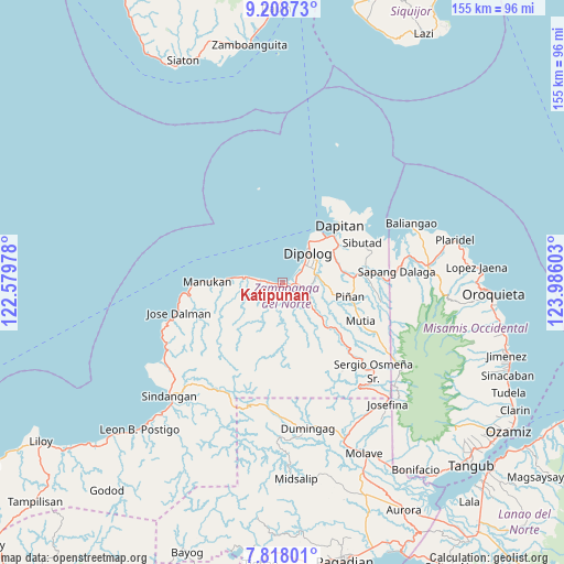
Katipunan GPS coordinates[2]
8° 30' 50.4" North, 123° 16' 58.44" East
| Map corner | latitude | longitude |
|---|---|---|
| Upper-left | 9.20873°, | 122.57978° |
| Center: | 8.514°, | 123.2829° |
| Lower-right: | 7.81801°, | 123.98603° |
| Map W x H: | 154.6×154.6 km | = 96.1×96.1mi |
| max Lat: | 20.78733° ⇑78.6% North |
| Katipunan: | 8.514° |
| min Lat: | ⇓21.4% South 4.65442° |
| min Long | Katipunan | max Long |
| 117.04868° | 123.2829° | 126.58417° |
| W 57.9%⇐ | ⇒42.1% E |
Elevation
Elevation of Katipunan is 3 m = 10 ft, and this is 84.9 m = 279 ft below average elevation for this country.
| Max E: |
2262 m = 7421 ft | 98.1% |
| Avg. | 87.9 m = 288 ft | |
| Katipunan | 3 m = 10 ft | |
Min E: |
-2 m = -7 ft | 1.9% |
See also: Philippines elevation on elevation.city.
Geographical zone
Katipunan is located in North Torrid zone (between Equator and Tropic of Cancer). Distance of Equator is 946.7 km =588.3 mi to South.| Distance of | km | miles | from Katipunan |
|---|---|---|---|
| North Pole | 9060.4 | 5629.9 | to North |
| Arctic Circle | 6454.5 | 4010.6 | to North |
| Tropic Cancer | 1659.3 | 1031 | to North |
| Equator | 946.7 | 588.3 | to South |


Nearby cities:
15 places around Katipunan: (largest is in red/bold)
• Barcelona
19.4 km =12.1 mi,  85°
85°
• Dapitan
22 km =13.7 mi,  44°
44°
• Dipolog
8.2 km =5.1 mi, 44°
• Ilaya
16.6 km =10.3 mi,  77°
77°
• Irasan
8.6 km =5.3 mi,  278°
278°
• Langatian
5.6 km =3.5 mi, 277°
• Linay
16.4 km =10.2 mi,  271°
271°
• Lingasan
13 km =8.1 mi,  98°
98°
• Manukan
20.2 km =12.6 mi, 276°
• Olingan
5 km =3.1 mi,  57°
57°
• Polanco
8.9 km =5.5 mi, 76°
• Ponot
29.5 km =18.3 mi,  256°
256°
• Sapang Dalaga
30.9 km =19.2 mi, 84°
• Seres
4.3 km =2.7 mi,  210°
210°
• Sibutao
23.9 km =14.9 mi,  68°
68°
Sources, notices
• [Note1] Compared only with cities in Philippines existing in our database
• [Src1] Map data: © OpenStreetMap contributors (CC-BY-SA)
• [Src2] Other city data from geonames.org with taken over terms of usage.
• [Src3] Geographical zone / Annual Mean Temperature by Robert A. Rohde @ Wikipedia
