Santo Tomas geodata
Santo Tomas (Calabarzon) is a seat of a third-order administrative division; located in Philippines in Asia/Manila (GMT+8) time zone. With population of 57,438 people, there are 162 cities with bigger population in this country. Compared to other cities in Philippines, 70.5% of cities are located further ↓South; 72.7% of cities are located further →East and 85.4% of cities have lower elevation than Santo Tomas. Note1


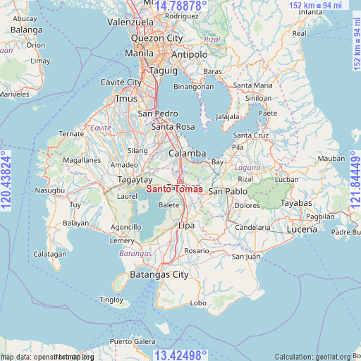
Santo Tomas GPS coordinates[2]
14° 6' 28.44" North, 121° 8' 28.896" East
| Map corner | latitude | longitude |
|---|---|---|
| Upper-left | 14.78878°, | 120.43824° |
| Center: | 14.1079°, | 121.14136° |
| Lower-right: | 13.42498°, | 121.84449° |
| Map W x H: | 151.6×151.6 km | = 94.2×94.2mi |
| max Lat: | 20.78733° ⇑29.5% North |
| Santo Tomas: | 14.1079° |
| min Lat: | ⇓70.5% South 4.65442° |
| min Long | Santo Tomas | max Long |
| 117.04868° | 121.14136° | 126.58417° |
| W 27.3%⇐ | ⇒72.7% E |
Elevation
Elevation of Santo Tomas is 145 m = 476 ft, and this is 57.1 m = 187 ft above average elevation for this country.
| Max E: |
2262 m = 7421 ft | 14.6% |
| Santo Tomas | 145 m 476 ft | |
| Avg. | 87.9 m = 288 ft | |
Min E: |
-2 m = -7 ft | 85.4% |
See also: Santo Tomas elevation on elevation.city.
Geographical zone
Santo Tomas is located in North Torrid zone (between Equator and Tropic of Cancer). Distance of this Northern Tropic circle is 1037.3 km =644.5 mi to North.| Distance of | km | miles | from Santo Tomas |
|---|---|---|---|
| North Pole | 8438.4 | 5243.4 | to North |
| Arctic Circle | 5832.5 | 3624.1 | to North |
| Tropic Cancer | 1037.3 | 644.5 | to North |
| Equator | 1568.7 | 974.7 | to South |


Nearby cities:
15 places around Santo Tomas: (largest is in red/bold)
• Ambulong
8.9 km =5.5 mi,  255°
255°
• Balele
7 km =4.3 mi,  227°
227°
• Bilog-Bilog
5.7 km =3.5 mi,  276°
276°
• Bitin
8.7 km =5.4 mi,  83°
83°
• Boot
9.8 km =6.1 mi,  224°
224°
• Janopol
5.6 km =3.5 mi,  243°
243°
• Malvar
7.3 km =4.5 mi,  165°
165°
• Pantay Na Matanda
2.4 km =1.5 mi,  296°
296°
• Prinza
9.8 km =6.1 mi,  357°
357°
• San Andres
10.4 km =6.5 mi,  128°
128°
• San Isidro
9 km =5.6 mi,  202°
202°
• San Pedro One
6.1 km =3.8 mi,  175°
175°
• Santor
3.8 km =2.4 mi,  248°
248°
• Tanauan
2.6 km =1.6 mi,  159°
159°
• Tranca
9.1 km =5.7 mi, 277°
Sources, notices
• [Note1] Compared only with cities in Philippines existing in our database
• [Src1] Map data: © OpenStreetMap contributors (CC-BY-SA)
• [Src2] Other city data from geonames.org with taken over terms of usage.
• [Src3] Geographical zone / Annual Mean Temperature by Robert A. Rohde @ Wikipedia
