Tranca geodata
Tranca (Calabarzon) is a populated place; located in Philippines in Asia/Manila (GMT+8) time zone. With population of 2,445 people, there are 3390 cities with bigger population in this country. Compared to other cities in Philippines, 70.8% of cities are located further ↓South; 74.9% of cities are located further →East and 88.5% of cities have lower elevation than Tranca. Note1


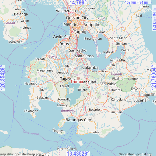
Tranca GPS coordinates[2]
14° 7' 5.34" North, 121° 3' 26.676" East
| Map corner | latitude | longitude |
|---|---|---|
| Upper-left | 14.799°, | 120.35429° |
| Center: | 14.11815°, | 121.05741° |
| Lower-right: | 13.43526°, | 121.76054° |
| Map W x H: | 151.6×151.6 km | = 94.2×94.2mi |
| max Lat: | 20.78733° ⇑29.2% North |
| Tranca: | 14.11815° |
| min Lat: | ⇓70.8% South 4.65442° |
| min Long | Tranca | max Long |
| 117.04868° | 121.05741° | 126.58417° |
| W 25.1%⇐ | ⇒74.9% E |
Elevation
Elevation of Tranca is 194 m = 636 ft, and this is 106.1 m = 348 ft above average elevation for this country.
| Max E: |
2262 m = 7421 ft | 11.5% |
| Tranca | 194 m 636 ft | |
| Avg. | 87.9 m = 288 ft | |
Min E: |
-2 m = -7 ft | 88.5% |
See also: Philippines elevation on elevation.city.
Geographical zone
Tranca is located in North Torrid zone (between Equator and Tropic of Cancer). Distance of this Northern Tropic circle is 1036.1 km =643.8 mi to North.| Distance of | km | miles | from Tranca |
|---|---|---|---|
| North Pole | 8437.3 | 5242.7 | to North |
| Arctic Circle | 5831.4 | 3623.5 | to North |
| Tropic Cancer | 1036.1 | 643.8 | to North |
| Equator | 1569.8 | 975.4 | to South |


Nearby cities:
15 places around Tranca: (largest is in red/bold)
• Ambulong
3.4 km =2.1 mi,  172°
172°
• Balele
7.1 km =4.4 mi,  146°
146°
• Bilog-Bilog
3.4 km =2.1 mi,  98°
98°
• Boot
8.3 km =5.2 mi, 165°
• Janopol
5.4 km =3.4 mi,  131°
131°
• Lumil
8.7 km =5.4 mi,  323°
323°
• Malabag
10.7 km =6.6 mi,  292°
292°
• Pantay Na Matanda
6.9 km =4.3 mi,  90°
90°
• Patuto
9.8 km =6.1 mi,  269°
269°
• Sampaloc
9.9 km =6.2 mi,  250°
250°
• San Isidro
11 km =6.8 mi, 149°
• Santo Tomas
9.1 km =5.7 mi, 97°
• Santor
6.1 km =3.8 mi,  114°
114°
• Talisay
4.8 km =3 mi,  233°
233°
• Tanauan
10.6 km =6.6 mi, 109°
Sources, notices
• [Note1] Compared only with cities in Philippines existing in our database
• [Src1] Map data: © OpenStreetMap contributors (CC-BY-SA)
• [Src2] Other city data from geonames.org with taken over terms of usage.
• [Src3] Geographical zone / Annual Mean Temperature by Robert A. Rohde @ Wikipedia
