San Andres geodata
San Andres (Calabarzon) is a populated place; located in Philippines in Asia/Manila (GMT+8) time zone. With population of 5,527 people, there are 1149 cities with bigger population in this country. Compared to other cities in Philippines, 69.8% of cities are located further ↓South; 71.4% of cities are located further →East and 90.5% of cities have lower elevation than San Andres. Note1


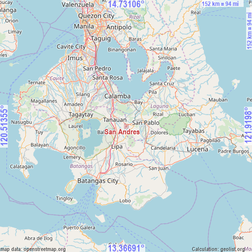
San Andres GPS coordinates[2]
14° 3' 0" North, 121° 13' 0.012" East
| Map corner | latitude | longitude |
|---|---|---|
| Upper-left | 14.73106°, | 120.51355° |
| Center: | 14.05°, | 121.21667° |
| Lower-right: | 13.36691°, | 121.9198° |
| Map W x H: | 151.7×151.7 km | = 94.3×94.3mi |
| max Lat: | 20.78733° ⇑30.2% North |
| San Andres: | 14.05° |
| min Lat: | ⇓69.8% South 4.65442° |
| min Long | San Andres | max Long |
| 117.04868° | 121.21667° | 126.58417° |
| W 28.6%⇐ | ⇒71.4% E |
Elevation
Elevation of San Andres is 238 m = 781 ft, and this is 150.1 m = 492 ft above average elevation for this country.
| Max E: |
2262 m = 7421 ft | 9.5% |
| San Andres | 238 m 781 ft | |
| Avg. | 87.9 m = 288 ft | |
Min E: |
-2 m = -7 ft | 90.5% |
See also: Philippines elevation on elevation.city.
Geographical zone
San Andres is located in North Torrid zone (between Equator and Tropic of Cancer). Distance of this Northern Tropic circle is 1043.7 km =648.5 mi to North.| Distance of | km | miles | from San Andres |
|---|---|---|---|
| North Pole | 8444.8 | 5247.4 | to North |
| Arctic Circle | 5839 | 3628.2 | to North |
| Tropic Cancer | 1043.7 | 648.5 | to North |
| Equator | 1562.2 | 970.7 | to South |


Nearby cities:
15 places around San Andres: (largest is in red/bold)
• Alaminos
3.6 km =2.2 mi,  64°
64°
• Bautista
9 km =5.6 mi,  133°
133°
• Bitin
7.4 km =4.6 mi,  4°
4°
• Malabanan
10.6 km =6.6 mi,  238°
238°
• Malvar
6.3 km =3.9 mi,  264°
264°
• San Andres
8.7 km =5.4 mi,  233°
233°
• San Gregorio
5.6 km =3.5 mi,  113°
113°
• San Joaquin
0.4 km =0.2 mi,  147°
147°
• San Juan
1.6 km =1 mi, 59°
• San Pedro One
7.7 km =4.8 mi,  272°
272°
• Santa Cruz
10.3 km =6.4 mi,  44°
44°
• Santiago
7.5 km =4.7 mi,  115°
115°
• Santo Tomas
10.4 km =6.5 mi,  308°
308°
• Talisay
8.9 km =5.5 mi,  188°
188°
• Tanauan
8.3 km =5.2 mi,  299°
299°
Sources, notices
• [Note1] Compared only with cities in Philippines existing in our database
• [Src1] Map data: © OpenStreetMap contributors (CC-BY-SA)
• [Src2] Other city data from geonames.org with taken over terms of usage.
• [Src3] Geographical zone / Annual Mean Temperature by Robert A. Rohde @ Wikipedia
