Santa Teresa geodata
Santa Teresa (Western Visayas) is a populated place; located in Philippines in Asia/Manila (GMT+8) time zone. With population of 4,000 people, there are 1731 cities with bigger population in this country. Compared to other cities in Philippines, 62.2% of cities are located further ↑North; 53.5% of cities are located further →East and 80.1% of cities have lower elevation than Santa Teresa. Note1


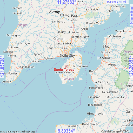
Santa Teresa GPS coordinates[2]
10° 35' 7.656" North, 122° 33' 37.44" East
| Map corner | latitude | longitude |
|---|---|---|
| Upper-left | 11.27582°, | 121.85728° |
| Center: | 10.58546°, | 122.5604° |
| Lower-right: | 9.89354°, | 123.26353° |
| Map W x H: | 153.7×153.7 km | = 95.5×95.5mi |
| max Lat: | 20.78733° ⇑62.2% North |
| Santa Teresa: | 10.58546° |
| min Lat: | ⇓37.8% South 4.65442° |
| min Long | Santa Teresa | max Long |
| 117.04868° | 122.5604° | 126.58417° |
| W 46.5%⇐ | ⇒53.5% E |
Elevation
Elevation of Santa Teresa is 93 m = 305 ft, and this is 5.1 m = 17 ft above average elevation for this country.
| Max E: |
2262 m = 7421 ft | 19.9% |
| Santa Teresa | 93 m 305 ft | |
| Avg. | 87.9 m = 288 ft | |
Min E: |
-2 m = -7 ft | 80.1% |
See also: Philippines elevation on elevation.city.
Geographical zone
Santa Teresa is located in North Torrid zone (between Equator and Tropic of Cancer). Distance of Equator is 1177 km =731.4 mi to South.| Distance of | km | miles | from Santa Teresa |
|---|---|---|---|
| North Pole | 8830.1 | 5486.8 | to North |
| Arctic Circle | 6224.2 | 3867.5 | to North |
| Tropic Cancer | 1428.9 | 887.9 | to North |
| Equator | 1177 | 731.4 | to South |


Nearby cities:
15 places around Santa Teresa: (largest is in red/bold)
• Cagbang
14.4 km =8.9 mi,  332°
332°
• Calaya
12.6 km =7.8 mi,  145°
145°
• Concordia
8.7 km =5.4 mi,  187°
187°
• Constancia
8.9 km =5.5 mi,  82°
82°
• Iloilo
12.4 km =7.7 mi,  2°
2°
• Jordan
9 km =5.6 mi,  25°
25°
• Locmayan
13.3 km =8.3 mi,  199°
199°
• Morobuan
4.5 km =2.8 mi,  352°
352°
• Nueva Valencia
8.9 km =5.5 mi, 200°
• Oracon
12.2 km =7.6 mi,  167°
167°
• Piña
10.4 km =6.5 mi,  54°
54°
• Rizal
13.5 km =8.4 mi,  36°
36°
• Salvacion
12.5 km =7.8 mi, 29°
• San Miguel
3.4 km =2.1 mi,  69°
69°
• San Nicolas
13.1 km =8.1 mi, 327°
Sources, notices
• [Note1] Compared only with cities in Philippines existing in our database
• [Src1] Map data: © OpenStreetMap contributors (CC-BY-SA)
• [Src2] Other city data from geonames.org with taken over terms of usage.
• [Src3] Geographical zone / Annual Mean Temperature by Robert A. Rohde @ Wikipedia
