Salvacion geodata
Salvacion (Western Visayas) is a populated place; located in Philippines in Asia/Manila (GMT+8) time zone. With population of 5,565 people, there are 1140 cities with bigger population in this country. Compared to other cities in Philippines, 61.2% of cities are located further ↑North; 52.8% of cities are located further →East and 56.1% of cities have higher elevation than Salvacion. Note1
Administrative division(s):
- Level 1: Western Visayas
- Level 2: Province of Guimaras
- Level 3: Buenavista


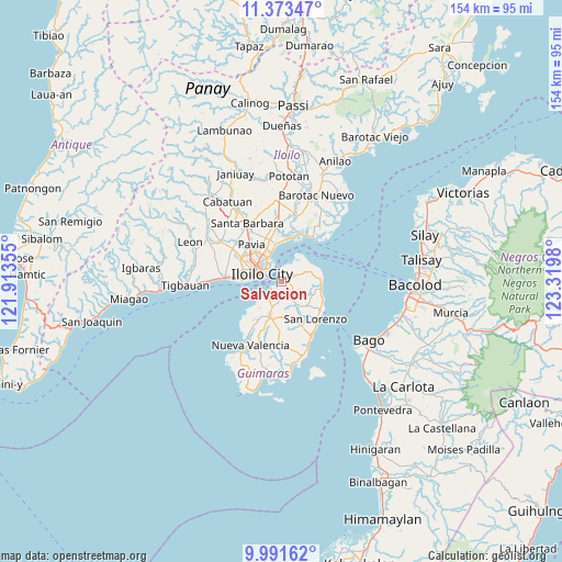
Salvacion GPS coordinates[2]
10° 40' 59.988" North, 122° 37' 0.012" East
| Map corner | latitude | longitude |
|---|---|---|
| Upper-left | 11.37347°, | 121.91355° |
| Center: | 10.68333°, | 122.61667° |
| Lower-right: | 9.99162°, | 123.3198° |
| Map W x H: | 153.6×153.6 km | = 95.4×95.4mi |
| max Lat: | 20.78733° ⇑61.2% North |
| Salvacion: | 10.68333° |
| min Lat: | ⇓38.8% South 4.65442° |
| min Long | Salvacion | max Long |
| 117.04868° | 122.61667° | 126.58417° |
| W 47.2%⇐ | ⇒52.8% E |
Elevation
Elevation of Salvacion is 19 m = 62 ft, and this is 68.9 m = 226 ft below average elevation for this country.
| Max E: |
2262 m = 7421 ft | 56.1% |
| Avg. | 87.9 m = 288 ft | |
| Salvacion | 19 m = 62 ft | |
Min E: |
-2 m = -7 ft | 43.9% |
See also: Philippines elevation on elevation.city.
Geographical zone
Salvacion is located in North Torrid zone (between Equator and Tropic of Cancer). Distance of Equator is 1187.9 km =738.1 mi to South.| Distance of | km | miles | from Salvacion |
|---|---|---|---|
| North Pole | 8819.2 | 5480 | to North |
| Arctic Circle | 6213.3 | 3860.8 | to North |
| Tropic Cancer | 1418 | 881.1 | to North |
| Equator | 1187.9 | 738.1 | to South |


Nearby cities:
15 places around Salvacion: (largest is in red/bold)
• Avila
10.1 km =6.3 mi,  84°
84°
• Buenavista
2.3 km =1.4 mi,  30°
30°
• Constancia
10.1 km =6.3 mi,  164°
164°
• East Valencia
10.3 km =6.4 mi,  99°
99°
• Getulio
8.9 km =5.5 mi,  37°
37°
• Iloilo
5.9 km =3.7 mi,  284°
284°
• Jordan
3.6 km =2.2 mi,  218°
218°
• Leganes
11.9 km =7.4 mi,  345°
345°
• Morobuan
9.3 km =5.8 mi,  226°
226°
• Pakiad
10.6 km =6.6 mi,  287°
287°
• Piña
5.4 km =3.4 mi,  154°
154°
• Rizal
1.8 km =1.1 mi,  90°
90°
• San Enrique
11.5 km =7.1 mi,  106°
106°
• San Miguel
10.1 km =6.3 mi,  196°
196°
• Ungca
10.4 km =6.5 mi,  315°
315°
Sources, notices
• [Note1] Compared only with cities in Philippines existing in our database
• [Src1] Map data: © OpenStreetMap contributors (CC-BY-SA)
• [Src2] Other city data from geonames.org with taken over terms of usage.
• [Src3] Geographical zone / Annual Mean Temperature by Robert A. Rohde @ Wikipedia
