Natividad geodata
Natividad (Ilocos) is a seat of a third-order administrative division; located in Philippines in Asia/Manila (GMT+8) time zone. With population of 5,828 people, there are 1078 cities with bigger population in this country. Compared to other cities in Philippines, 88.2% of cities are located further ↓South; 82.2% of cities are located further →East and 80.4% of cities have lower elevation than Natividad. Note1


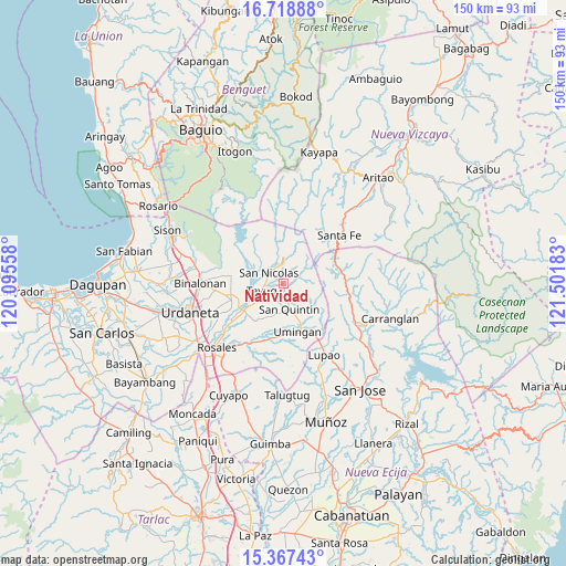
Natividad GPS coordinates[2]
16° 2' 39.48" North, 120° 47' 55.32" East
| Map corner | latitude | longitude |
|---|---|---|
| Upper-left | 16.71888°, | 120.09558° |
| Center: | 16.0443°, | 120.7987° |
| Lower-right: | 15.36743°, | 121.50183° |
| Map W x H: | 150.3×150.3 km | = 93.4×93.4mi |
| max Lat: | 20.78733° ⇑11.8% North |
| Natividad: | 16.0443° |
| min Lat: | ⇓88.2% South 4.65442° |
| min Long | Natividad | max Long |
| 117.04868° | 120.7987° | 126.58417° |
| W 17.8%⇐ | ⇒82.2% E |
Elevation
Elevation of Natividad is 94 m = 308 ft, and this is 6.1 m = 20 ft above average elevation for this country.
| Max E: |
2262 m = 7421 ft | 19.6% |
| Natividad | 94 m 308 ft | |
| Avg. | 87.9 m = 288 ft | |
Min E: |
-2 m = -7 ft | 80.4% |
See also: Philippines elevation on elevation.city.
Geographical zone
Natividad is located in North Torrid zone (between Equator and Tropic of Cancer). Distance of this Northern Tropic circle is 822 km =510.8 mi to North.| Distance of | km | miles | from Natividad |
|---|---|---|---|
| North Pole | 8223.1 | 5109.6 | to North |
| Arctic Circle | 5617.2 | 3490.4 | to North |
| Tropic Cancer | 822 | 510.8 | to North |
| Equator | 1784 | 1108.5 | to South |


Nearby cities:
15 places around Natividad: (largest is in red/bold)
• Alac
6.3 km =3.9 mi,  172°
172°
• Bantog
12 km =7.5 mi,  250°
250°
• Cabalaoangan
7 km =4.3 mi,  193°
193°
• Cabalitian
4.9 km =3 mi,  351°
351°
• Carriedo
4.9 km =3 mi, 252°
• Guiset East
12.6 km =7.8 mi,  281°
281°
• Lagasit
5.7 km =3.5 mi, 185°
• Magallanes
6.9 km =4.3 mi, 246°
• Nancalobasaan
13.1 km =8.1 mi,  159°
159°
• Panganiban
4.8 km =3 mi,  211°
211°
• San Manuel
14.1 km =8.8 mi, 279°
• San Nicolas
4.8 km =3 mi,  306°
306°
• San Quintin
6.7 km =4.2 mi, 166°
• Santa Maria
12.7 km =7.9 mi,  236°
236°
• Tayug
6.2 km =3.9 mi, 252°
Sources, notices
• [Note1] Compared only with cities in Philippines existing in our database
• [Src1] Map data: © OpenStreetMap contributors (CC-BY-SA)
• [Src2] Other city data from geonames.org with taken over terms of usage.
• [Src3] Geographical zone / Annual Mean Temperature by Robert A. Rohde @ Wikipedia
