Burgos geodata
Burgos (Central Luzon) is a populated place; located in Philippines in Asia/Manila (GMT+8) time zone. With population of 3,727 people, there are 1896 cities with bigger population in this country. Compared to other cities in Philippines, 88.4% of cities are located further ↓South; 75.1% of cities are located further →East and 94.8% of cities have lower elevation than Burgos. Note1
Administrative division(s):
- Level 1: Central Luzon
- Level 2: Province of Nueva Ecija
- Level 3: Carranglan


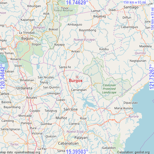
Burgos GPS coordinates[2]
16° 4' 18.516" North, 121° 2' 58.344" East
| Map corner | latitude | longitude |
|---|---|---|
| Upper-left | 16.74629°, | 120.34642° |
| Center: | 16.07181°, | 121.04954° |
| Lower-right: | 15.39503°, | 121.75267° |
| Map W x H: | 150.2×150.2 km | = 93.3×93.3mi |
| max Lat: | 20.78733° ⇑11.6% North |
| Burgos: | 16.07181° |
| min Lat: | ⇓88.4% South 4.65442° |
| min Long | Burgos | max Long |
| 117.04868° | 121.04954° | 126.58417° |
| W 24.9%⇐ | ⇒75.1% E |
Elevation
Elevation of Burgos is 402 m = 1319 ft, and this is 314.1 m = 1031 ft above average elevation for this country.
| Max E: |
2262 m = 7421 ft | 5.2% |
| Burgos | 402 m 1319 ft | |
| Avg. | 87.9 m = 288 ft | |
Min E: |
-2 m = -7 ft | 94.8% |
See also: Philippines elevation on elevation.city.
Geographical zone
Burgos is located in North Torrid zone (between Equator and Tropic of Cancer). Distance of this Northern Tropic circle is 818.9 km =508.8 mi to North.| Distance of | km | miles | from Burgos |
|---|---|---|---|
| North Pole | 8220 | 5107.7 | to North |
| Arctic Circle | 5614.2 | 3488.5 | to North |
| Tropic Cancer | 818.9 | 508.8 | to North |
| Equator | 1787 | 1110.4 | to South |


Nearby cities:
15 places around Burgos: (largest is in red/bold)
• Aritao
25.2 km =15.7 mi,  356°
356°
• Banganan
27 km =16.8 mi,  1°
1°
• Belance
24.7 km =15.3 mi,  59°
59°
• Bone South
20.1 km =12.5 mi,  343°
343°
• Carranglan
12.4 km =7.7 mi,  172°
172°
• Conversion
21 km =13 mi,  156°
156°
• Digdig
15.7 km =9.8 mi,  209°
209°
• Lupao
26.8 km =16.7 mi,  217°
217°
• Malasin
26.6 km =16.5 mi,  13°
13°
• Nancalobasaan
26.9 km =16.7 mi,  235°
235°
• Natividad
27 km =16.8 mi,  263°
263°
• Puncan
19.4 km =12.1 mi,  198°
198°
• San Quintin
27 km =16.8 mi,  249°
249°
• Santa Fe
15.4 km =9.6 mi,  309°
309°
• Tayabo
26.5 km =16.5 mi,  184°
184°
Sources, notices
• [Note1] Compared only with cities in Philippines existing in our database
• [Src1] Map data: © OpenStreetMap contributors (CC-BY-SA)
• [Src2] Other city data from geonames.org with taken over terms of usage.
• [Src3] Geographical zone / Annual Mean Temperature by Robert A. Rohde @ Wikipedia
